Log InRegister
Search For:
Mineral Name:
Locality Name:
Keyword(s):
 
Home PageAbout MindatThe Mindat ManualHistory of MindatCopyright StatusWho We AreOur ScienceMindat Newsletter [Free Download]Contact Us
Donate to MindatSponsor a PageCorporate SponsorshipSponsored Pages
Learning CenterWhat Is a Mineral?The Most Common Minerals on EarthInformation for EducatorsMindat ArticlesMindat Newsletter [Free Download]The ElementsThe Mineral Quiz
Search FormMinerals by PropertiesMinerals by ChemistryMineral Visual ExplorerAdvanced Locality SearchRandom MineralRandom LocalitySearch by minIDMinerals by CountryAlphabetical Mineral IndexAlphabetical Locality SearchMineral Association SearchList of CountriesLocalities Near MePhoto SearchSearch ArticlesSearch GlossaryThe Rock H. Currier Digital LibraryMore Search Options
The Mindat ManualAdd a New PhotoRate PhotosLocality Edit ReportCoordinate Completion ReportAdd Glossary Item
MineralsPetrologyFossilsMeteoritesGeologic Time
Mining CompaniesStatisticsMineral MuseumsClubs & OrganizationsMineral Shows & EventsDevice SettingsTime Machine
Read DiscussionsIdentification Request
Photo SearchPhoto GalleriesSearch by ColourPhoto Colour ExplorerNew Photos TodayNew Photos YesterdayMembers' Photo GalleriesPast Photo of the Day GalleryPhotography

Corundum from
Mistral Ruby Mine (Hillrise Prospect), Spriggs Creek Bore (Spriggs Bore), Ambalindum Station, Harts Range, Central Desert Region, Northern Territory, Australia


Locality type:Mine
Classification
Species:Corundum
Formula:Al2O3
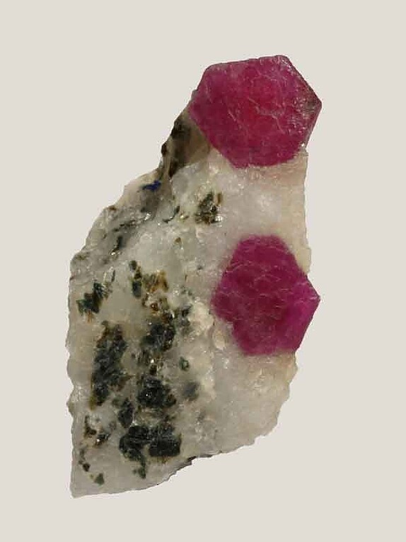
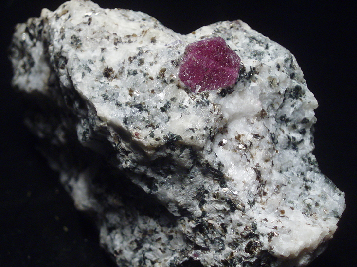
Comments:McColl & Warren state that: "The ruby occurs either as well-formed hexagonal tabular crystals up to 5 cm in diameter and 1 cm thick, .... or as roughly ovoid masses up to 12 cm long, which are single crystals without external form. The smaller discrete crystals generally show the best ruby colour. The larger pieces are hexagonally zoned in shades of red ..... and are generally more opaque. The largest single fragments recovered weigh about half a kilogram. Very little fully transparent ruby has been found: the small to medium size crystals are commonly translucent .... , but in the larger pieces are grossly clouded with fine gas filled fissures roughly following the rhombohedral parting directions..... Scarce mica flakes (phlogopite?), and accessory rounded subhedral zircon, are present as inclusions in the peripheral zones of some crystals".
Confirmation
Validity:Believed Valid
Associated Minerals Based on Photo Data:
Diaspore1
Data
Mineral Data:Click here to view Corundum data
Locality Data:Click here to view Mistral Ruby Mine (Hillrise Prospect), Spriggs Creek Bore (Spriggs Bore), Ambalindum Station, Harts Range, Central Desert Region, Northern Territory, Australia
Photo GalleryView Gallery (2 photos)
Data Identifiers
Mindat Occurrence Record ID:986457
Long-form Identifier:1:3:986457:3
GUID (UUID V4):0
Nearest other occurrences of Corundum
13.6km (8.4 miles) ⓘHarts Range, Central Desert Region, Northern Territory, Australia
21.0km (13.0 miles) ⓘUn-named Epidote Deposit, Spriggs Creek Bore (Spriggs Bore), Ambalindum Station, Harts Range, Central Desert Region, Northern Territory, Australia
24.5km (15.2 miles) ⓘInkamulla Sapphire Deposit, Spriggs Creek Bore (Spriggs Bore), Ambalindum Station, Harts Range, Central Desert Region, Northern Territory, Australia
28.7km (17.8 miles) ⓘ'Western Diggings' Iolite Deposit, Spriggs Creek Bore (Spriggs Bore), Ambalindum Station, Harts Range, Central Desert Region, Northern Territory, Australia
30.6km (19.0 miles) ⓘShaw's Iolite Deposit, Spriggs Creek Bore (Spriggs Bore), Ambalindum Station, Harts Range, Central Desert Region, Northern Territory, Australia
37.8km (23.5 miles) ⓘUnnamed kornerupine location (W), Mount Riddock Station, Harts Range, Central Desert Region, Northern Territory, Australia
38.3km (23.8 miles) ⓘHuckitta Bore (Huckitta Well), Coggan Bore, Ambalindum Station, Harts Range, Central Desert Region, Northern Territory, Australia
39.3km (24.4 miles) ⓘEntia Valley, Ambalindum Station, Harts Range, Central Desert Region, Northern Territory, Australia
44.2km (27.5 miles) ⓘArltunga Gold Field, Central Desert Region, Northern Territory, Australia
86.8km (53.9 miles) ⓘJohannsen's Phlogopite Mine, Strangways Range, Central Desert Region, Northern Territory, Australia
References
 
and/or  
Mindat.org® is an outreach project of the Hudson Institute of Mineralogy, a 501(c)(3) not-for-profit organization. Mindat® and mindat.org® are registered trademarks of the Hudson Institute of Mineralogy.
Copyright © mindat.org and the Hudson Institute of Mineralogy 1993-2026, except where stated. Most political location boundaries are © OpenStreetMap contributors. Mindat.org relies on the contributions of thousands of members and supporters. Founded in 2000 by Jolyon Ralph and Ida Chau.
Content on this site may not be used to train, fine-tune, or otherwise develop artificial intelligence or machine learning models without prior written permission - see our Terms & Conditions.
To cite: Ralph, J., Von Bargen, D., Martynov, P., Zhang, J., Que, X., Prabhu, A., Morrison, S. M., Li, W., Chen, W., & Ma, X. (2025). Mindat.org: The open access mineralogy database to accelerate data-intensive geoscience research. American Mineralogist, 110(6), 833–844. doi:10.2138/am-2024-9486.
Privacy Policy - Terms & Conditions - Contact Us / DMCA issues - Report a bug/vulnerability Current server date and time: October 20, 2026 08:06:07
Go to top of page