Log In


Emperius Mine, Creede Mining District, Mineral County, Colorado, USAi
| Regional Level Types | |
|---|---|
| Emperius Mine | Mine |
| Creede Mining District | Mining District |
| Mineral County | County |
| Colorado | State |
| USA | Country |
This page is currently not sponsored. Click here to sponsor this page.


Latitude & Longitude (WGS84):
37° 52' 14'' North , 106° 55' 46'' West
Latitude & Longitude (decimal):
Type:
Deposit first discovered:
1884
Köppen climate type:
Nearest Settlements:
| Place | Population | Distance |
|---|---|---|
| Creede | 405 (2011) | 2.4km |
| South Fork | 362 (2017) | 33.8km |
| Alpine | 174 (2011) | 36.1km |
| Gerrard | 278 (2011) | 36.5km |
| Lake City | 367 (2017) | 38.2km |
Other/historical names associated with this locality:
Emperious Mining Company; Del Monte Mining Company; Chance Mining Company; Commodore Mining Company; Bachelor Mine; Amethyst Mine; New York Mine; Creede Mines
A former Zn-Ag-Pb-Cu-Au-Cd-Sb-As occurrence/mine located in the SE¼NW¼SE¼ sec. 24, T42N, R1W, NMM. Discovered in 1884. The year of first initial production was 1892. Subsequent production occurred starting in 1942 and ended in 1976. Owned and operated by the Emperius Mining Company (1960). Owned by Minerals Engineering Co. (MECO), Grand Junction, Colorado (1980). Operated by Pioneer Nuclear, Inc. (1982-). Mineral rights include patented (private) claims, private lease and located claims.
Individual mines were located and developed in the early 1890s and were consolidated into the Emperius Mining Company in 1942, acquired by Minerals Engineering Co. (MECO) in 1973. Exploration since then has been carried out by MECO's operators, Chevron Resources and Harrison-Western.
The USGS Emperius Mine record is a consolidation of data from the Happy Thought, Last Chance, New York, Del Monte, Amethyst, Commodore and Bachelor Mines.
Mineralization is a polymetallic deposit hosted in Oligocene rhyolite of the Campbell Mountain Member of the Bachelor Mountain rhyolite and the Willow Creek Member of the Bachelor Mountain rhyolite. The orebody strikes N15 to 30W, dips 55 to 70SW and is 250 meters wide, 1.4 meters thick, 4,800 meters long and covers an area of 20 hectares. The depth-to-top is 100 meters. Orebody No. 1 is a fissure vein and tabular. Orebody No. 2 is a breccia fill and tabular. Orebody No. 3 is a shear zone and tabular. The primary mode of origin was hydrothermal activity, and the secondary mode was oxidation. Primary ore control was faulting and the secondary control was igneous activity. Wall rock alteration is moderate (argillic, silicification, chloritization, Fe-Mn oxides plus Cu carbonates and propylitic). Factors in the ore control were the Amethyst Fault, the Ancestral Amethyst Fault, subparallel and antithetic fractures in the hanging wall. Local rocks include Oligocene sedimentary rocks.
Local geologic structures include the San Juan Volcanic Field; La Garita, Creede, and Bachelor Calderas, the Creede Graben and the Amethyst Fault Zone.
The principal lodes are in the Amethyst Fault (usually as fault contact between the Campbell Mountain rhyolite in the hanging wall and the Willow Creek rhyolite in the footwall), ancestral Amethyst (Dean) Fault, and in major hanging wall fractures and veins (Ohio and Winchester), subparallel to, and joining the Amethyst Fault at depth but striking farther West and dipping vertical to steeply NE and dying out upward into strongly altered rock. Deep mineralization is unoxidized base-metal vein type in chlorite gangue with little wall rock alteration. The central area is silicified with partly oxidized Ag-bearing ores in Fe-Mn, oxide-stained quartz-amethyst-baryte gangue in veins and disseminations. The upper oxidized ore is mostly disseminated in fractured, strongly argillized rock.
Tectonic Structure: Central Cordillera (Southern Rocky Mountains)
Workings include underground openings with an area of 88.225 HA. The overall depth is 569.98 meters, the overall length is 3,218.6 meters and the overall width is 274.32 meters. This includes all workings on the central, most of the southern, and part of the northern Amethyst vein. The mining method was shrinkage methods (overhand shrinkage). The milling method was flotation.
Production since 1942 was a consolidation of the Commodore, Amethyst and connected workings. No production was reported for 1945, 1971, 1973, 1977 through 1980. In addition to Cd produced in 1970, unspecified amounts of Cd were reported for 1965 and 1967. The amounts of principal metals for 1942-1950 were calculated from reported ore grades.
Chevron Resources (a division of Standard Oil of California) signed an option with MECO in 1978 for a 5-year lease for exploration in the Emperius Mine.
During 1978, Chevron conducted an extensive underground sampling, geologic and mapping program that encountered encouraging Ag mineralization in older workings and generally confirmed previous sampling work. In 1979, Chevron continued the drilling program started in 1978. During 1980 Chevron expanded its exploration effort to include approximately 3,450 feet (ca. 1 km) of underground drifting and bulk sampling, that was conducted by an independent contractor. By the end of January 1981, Chevron had completed approximately 130 surface and underground drill holes totalling over 41,000 feet (12.5 km). Several mine levels had been sampled in detail, and geophysical and geochemical surveys were conducted over much of the southern portion of the optioned claims. The results indicate the presence of widespread, low-grade, disseminated Ag mineralization adjacent to the Amethyst fault.
Reserves and resources data: Type: in-situ (estimate year = 1975): Demonstrated: 218,599 metric tons of ore; Measured: 218,599 metric tons of ore; Total resources: 218,599 metric tons of ore.
Commodity:
Silver Ag 44.9 grams/metric ton
Lead Pb 5.14 weight%
Zinc Zn 6.6 weight%
Copper Cu 0.3799 weight%
Gold Au 0.51 grams/metric ton
Cadmium Cd 0.04 weight%
Type: in-situ (estimate year = 1975): Demonstrated: 322,000 metric tons of ore; Measured: 322,000 metric tons of ore; Total resources: 322,000 metric tons of ore.
Commodity:
Silver Ag 230 grams/metric ton
Lead Pb 1.32 weight%
Gold Au 0.24 grams/metric ton
Select Mineral List Type
Standard Detailed Gallery Strunz Chemical ElementsCommodity List
This is a list of exploitable or exploited mineral commodities recorded at this locality.Mineral List
19 valid minerals.
Rock Types Recorded
Note: data is currently VERY limited. Please bear with us while we work towards adding this information!
Select Rock List Type
Alphabetical List Tree DiagramDetailed Mineral List:
| ⓘ Anglesite Formula: PbSO4 |
| ⓘ Baryte Formula: BaSO4 |
| ⓘ Chalcocite Formula: Cu2S |
| ⓘ Chalcopyrite Formula: CuFeS2 |
| ⓘ Chlorargyrite Formula: AgCl |
| ⓘ 'Chlorite Group' |
| ⓘ Cuprite Formula: Cu2O References: |
| ⓘ Cuprite var. Chalcotrichite Formula: Cu2O |
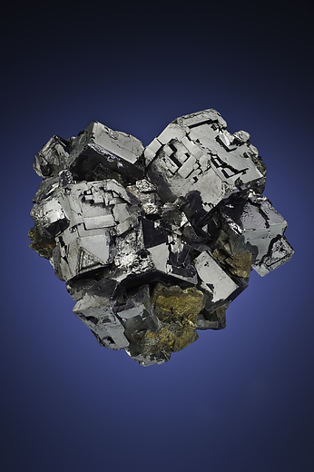
| ⓘ Galena Formula: PbS References: |
| ⓘ Gold Formula: Au |
| ⓘ Goslarite Formula: ZnSO4 · 7H2O |
| ⓘ Greenockite Formula: CdS |
| ⓘ Halotrichite Formula: FeAl2(SO4)4 · 22H2O Description: Originally described as pickeringite |
| ⓘ Hematite Formula: Fe2O3 |
| ⓘ Jarosite Formula: KFe3+3(SO4)2(OH)6 |
| ⓘ 'Limonite' |
| ⓘ Pyromorphite Formula: Pb5(PO4)3Cl |
| ⓘ Quartz Formula: SiO2 |
| ⓘ Quartz var. Amethyst Formula: SiO2 |
| ⓘ Rhodochrosite Formula: MnCO3 |
| ⓘ Silver Formula: Ag |
| ⓘ Smithsonite Formula: ZnCO3 |
| ⓘ Sphalerite Formula: ZnS References: |
| ⓘ 'Tennantite Subgroup' Formula: Cu6(Cu4C2+2)As4S12S |
| ⓘ 'Tetrahedrite Subgroup' Formula: Cu6(Cu4C2+2)Sb4S12S |
| ⓘ 'Wad' |

List of minerals arranged by Strunz 10th Edition classification
| Group 1 - Elements | |||
|---|---|---|---|
| ⓘ | Gold | 1.AA.05 | Au |
| ⓘ | Silver | 1.AA.05 | Ag |
| Group 2 - Sulphides and Sulfosalts | |||
| ⓘ | Chalcocite | 2.BA.05 | Cu2S |
| ⓘ | Sphalerite | 2.CB.05a | ZnS |
| ⓘ | Chalcopyrite | 2.CB.10a | CuFeS2 |
| ⓘ | Greenockite | 2.CB.45 | CdS |
| ⓘ | Galena | 2.CD.10 | PbS |
| ⓘ | 'Tennantite Subgroup' | 2.GB.05 | Cu6(Cu4C2+2)As4S12S |
| ⓘ | 'Tetrahedrite Subgroup' | 2.GB.05 | Cu6(Cu4C2+2)Sb4S12S |
| Group 3 - Halides | |||
| ⓘ | Chlorargyrite | 3.AA.15 | AgCl |
| Group 4 - Oxides and Hydroxides | |||
| ⓘ | Cuprite var. Chalcotrichite | 4.AA.10 | Cu2O |
| ⓘ | 4.AA.10 | Cu2O | |
| ⓘ | Hematite | 4.CB.05 | Fe2O3 |
| ⓘ | Quartz var. Amethyst | 4.DA.05 | SiO2 |
| ⓘ | 4.DA.05 | SiO2 | |
| Group 5 - Nitrates and Carbonates | |||
| ⓘ | Rhodochrosite | 5.AB.05 | MnCO3 |
| ⓘ | Smithsonite | 5.AB.05 | ZnCO3 |
| Group 7 - Sulphates, Chromates, Molybdates and Tungstates | |||
| ⓘ | Anglesite | 7.AD.35 | PbSO4 |
| ⓘ | Baryte | 7.AD.35 | BaSO4 |
| ⓘ | Jarosite | 7.BC.10 | KFe3+3(SO4)2(OH)6 |
| ⓘ | Goslarite | 7.CB.40 | ZnSO4 · 7H2O |
| ⓘ | Halotrichite | 7.CB.85 | FeAl2(SO4)4 · 22H2O |
| Group 8 - Phosphates, Arsenates and Vanadates | |||
| ⓘ | Pyromorphite | 8.BN.05 | Pb5(PO4)3Cl |
| Unclassified | |||
| ⓘ | 'Chlorite Group' | - | |
| ⓘ | 'Limonite' | - | |
| ⓘ | 'Wad' | - | |
List of minerals for each chemical element
Other Databases
| Link to USGS MRDS: | 10101728 |
|---|
Other Regions, Features and Areas containing this locality
North AmericaContinent
- Rocky MountainsMountain Range
North America PlateTectonic Plate
- Great Plains DomainDomain
- Southern Rocky MountainsOrogenic Belt
USA
- San Juan MountainsMountain Range
This page contains all mineral locality references listed on mindat.org. This does not claim to be a complete list. If you know of more minerals from this site, please register so you can add to our database. This locality information is for reference purposes only. You should never attempt to
visit any sites listed in mindat.org without first ensuring that you have the permission of the land and/or mineral rights holders
for access and that you are aware of all safety precautions necessary.

Emperius Mine, Creede Mining District, Mineral County, Colorado, USA