Log In


Wheal Ellen (Wheal Ellen North), Northampton, Northampton Shire, Western Australia, Australiai
| Regional Level Types | |
|---|---|
| Wheal Ellen (Wheal Ellen North) | Mine |
| Northampton | - not defined - |
| Northampton Shire | Shire |
| Western Australia | State |
| Australia | Country |
This page is currently not sponsored. Click here to sponsor this page.
Latitude & Longitude (WGS84):
28° 21' 28'' South , 114° 36' 51'' East
Latitude & Longitude (decimal):
Type:
Köppen climate type:
Nearest Settlements:
| Place | Population | Distance |
|---|---|---|
| Northampton | 1,043 (2014) | 2.5km |
| Isseka | 310 (2018) | 9.7km |
| Horrocks | 136 (2018) | 18.1km |
| Naraling | 273 (2018) | 21.9km |
| Ogilvie | 112 (2018) | 23.2km |
Locality: 2.5 km south west of Northampton.
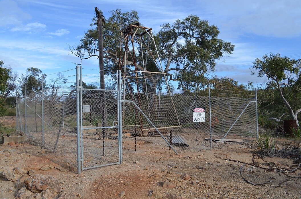
Located just south of the Horrocks Beach Road. The mullock heap has been encased in earth, and this crime means specimen collecting is not possible. A fenced shaft and concrete building foundations are all that remains of the mine. There are over two hundred historical mine locations in the region, all but the largest and most established lost.
The mine was opened by former Geraldine Mine Manager, Captain Samuel Mitchell, and Geraldton merchant, Charles Crowther. Their success in operating the mine in the early 1880's, led to the construction of Chiverton House in 1883, an imposing historic residence on the main street of Northampton. They were also responsible for opening the Baddera Mine north of Northampton. At these mines Mitchell incorporated new technology to treat previously disregarded carbonate ores of lead. Although successful for a time, the fluctuations of lead prices forced Mitchell to retire from mining and establish a successful store, assay office, and station agency in Northampton.
A 1906 inspection describes Wheal Ellen North as a separate locality although possibly mined in conjunction with Wheal Ellen. It does not describe how far north of the main mine it is. At the time it was on crown land, although this is unlikely today. A shaft had been sunk to 30 metres, showing lead ore in hard greenstone as part of the main Wheal Ellen lode. At this point the lode was small, and the mine flooded with water. There were further small workings to the north again showing a 12 inch vein of galena ore in greenstone dyke rock.
The main Wheal Ellen mine was described in 1906 as being formerly extensively worked, with large amounts of equipment left (not today). It was owned at this time by the Western Australian Smelting Company who had done little work on the deposit. At the time there were two shafts to 50 metres, on a lode 1 to 6 feet wide running north-east to south-west. The dumps showed galena and sphalerite.
Ferguson states the lode shear dips 60 to 80 degrees west, following the western contact of a thin dolerite dyke in granulite. The ore is associated with a link structure, which offsets the shear. Mined intermittently 1872-1882, and 1917-1967, the first period producing approximately 1000 tonnes of lead, and second period 23 545 tonnes of ore for 1935 tonnes of lead.
Select Mineral List Type
Standard Detailed Gallery Strunz Chemical ElementsMineral List
6 valid minerals.
Rock Types Recorded
Note: data is currently VERY limited. Please bear with us while we work towards adding this information!
Select Rock List Type
Alphabetical List Tree DiagramDetailed Mineral List:
| ⓘ Cerussite Formula: PbCO3 |
| ⓘ Chalcopyrite Formula: CuFeS2 |
| ⓘ Galena Formula: PbS |
| ⓘ Marcasite Formula: FeS2 |
| ⓘ Pyrite Formula: FeS2 |
| ⓘ Sphalerite Formula: ZnS |
Gallery:
List of minerals arranged by Strunz 10th Edition classification
| Group 2 - Sulphides and Sulfosalts | |||
|---|---|---|---|
| ⓘ | Sphalerite | 2.CB.05a | ZnS |
| ⓘ | Chalcopyrite | 2.CB.10a | CuFeS2 |
| ⓘ | Galena | 2.CD.10 | PbS |
| ⓘ | Pyrite | 2.EB.05a | FeS2 |
| ⓘ | Marcasite | 2.EB.10a | FeS2 |
| Group 5 - Nitrates and Carbonates | |||
| ⓘ | Cerussite | 5.AB.15 | PbCO3 |
List of minerals for each chemical element
| C | Carbon | |
|---|---|---|
| C | ⓘ Cerussite | PbCO3 |
| O | Oxygen | |
| O | ⓘ Cerussite | PbCO3 |
| S | Sulfur | |
| S | ⓘ Chalcopyrite | CuFeS2 |
| S | ⓘ Galena | PbS |
| S | ⓘ Marcasite | FeS2 |
| S | ⓘ Pyrite | FeS2 |
| S | ⓘ Sphalerite | ZnS |
| Fe | Iron | |
| Fe | ⓘ Chalcopyrite | CuFeS2 |
| Fe | ⓘ Marcasite | FeS2 |
| Fe | ⓘ Pyrite | FeS2 |
| Cu | Copper | |
| Cu | ⓘ Chalcopyrite | CuFeS2 |
| Zn | Zinc | |
| Zn | ⓘ Sphalerite | ZnS |
| Pb | Lead | |
| Pb | ⓘ Cerussite | PbCO3 |
| Pb | ⓘ Galena | PbS |
Other Regions, Features and Areas containing this locality
Australia
- Western Australia
- Pinjarra OrogenOrogen
- Northampton ProvinceGeologic Province
- Pinjarra OrogenOrogen
Australian PlateTectonic Plate
- Darling OrogenOrogenic Belt
This page contains all mineral locality references listed on mindat.org. This does not claim to be a complete list. If you know of more minerals from this site, please register so you can add to our database. This locality information is for reference purposes only. You should never attempt to
visit any sites listed in mindat.org without first ensuring that you have the permission of the land and/or mineral rights holders
for access and that you are aware of all safety precautions necessary.

Wheal Ellen, Northampton, Northampton Shire, Western Australia, Australia