Log In


Montaña Ayosa, Arafo, Tenerife, Santa Cruz de Tenerife Province, Canary Islands, Spaini
| Regional Level Types | |
|---|---|
| Montaña Ayosa | Mountain |
| Arafo | Municipality |
| Tenerife | Island |
| Santa Cruz de Tenerife Province | Province |
| Canary Islands | Group of Autonomous Communities |
| Spain | Country |
This page is currently not sponsored. Click here to sponsor this page.


Latitude & Longitude (WGS84):
28° 21' 21'' North , 16° 27' 47'' West
Latitude & Longitude (decimal):
Type:
Köppen climate type:
Nearest Settlements:
| Place | Population | Distance |
|---|---|---|
| Arafo | 5,375 (2012) | 4.4km |
| Güimar | 17,662 (2015) | 7.0km |
| La Orotava | 41,171 (2012) | 7.0km |
| Santa Úrsula | 14,013 (2012) | 8.2km |
| La Victoria de Acentejo | 8,469 (2012) | 8.5km |
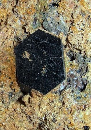
Montaña Ayosa, a prominent peak in northern Tenerife, Canary Islands, Spain, rises to approximately 2,076 meters (6,811 feet) above sea level. It lies within the Corona Forestal Natural Park, a protected area celebrated for its rich biodiversity and scenic landscapes. The peak is notable for its volcanic geology, especially tuff deposits containing well-formed crystals of augite and hornblende.
Select Mineral List Type
Standard Detailed Gallery Strunz Chemical ElementsDetailed Mineral List:
| ⓘ Augite Formula: (CaxMgyFez)(Mgy1Fez1)Si2O6 |
| ⓘ 'Hornblende Root Name Group' Formula: ◻Ca2(Z2+4Z3+)(AlSi7O22)(OH,F,Cl)2 |
| ⓘ Magnetite Formula: Fe2+Fe3+2O4 |

List of minerals arranged by Strunz 10th Edition classification
| Group 4 - Oxides and Hydroxides | |||
|---|---|---|---|
| ⓘ | Magnetite | 4.BB.05 | Fe2+Fe3+2O4 |
| Group 9 - Silicates | |||
| ⓘ | Augite | 9.DA.15 | (CaxMgyFez)(Mgy1Fez1)Si2O6 |
| Unclassified | |||
| ⓘ | 'Hornblende Root Name Group' | - | ◻Ca2(Z2+4Z3+)(AlSi7O22)(OH,F,Cl)2 |
List of minerals for each chemical element
| H | Hydrogen | |
|---|---|---|
| H | ⓘ Hornblende Root Name Group | ◻Ca2(Z42+Z3+)(AlSi7O22)(OH,F,Cl)2 |
| O | Oxygen | |
| O | ⓘ Augite | (CaxMgyFez)(Mgy1Fez1)Si2O6 |
| O | ⓘ Magnetite | Fe2+Fe23+O4 |
| O | ⓘ Hornblende Root Name Group | ◻Ca2(Z42+Z3+)(AlSi7O22)(OH,F,Cl)2 |
| F | Fluorine | |
| F | ⓘ Hornblende Root Name Group | ◻Ca2(Z42+Z3+)(AlSi7O22)(OH,F,Cl)2 |
| Mg | Magnesium | |
| Mg | ⓘ Augite | (CaxMgyFez)(Mgy1Fez1)Si2O6 |
| Al | Aluminium | |
| Al | ⓘ Hornblende Root Name Group | ◻Ca2(Z42+Z3+)(AlSi7O22)(OH,F,Cl)2 |
| Si | Silicon | |
| Si | ⓘ Augite | (CaxMgyFez)(Mgy1Fez1)Si2O6 |
| Si | ⓘ Hornblende Root Name Group | ◻Ca2(Z42+Z3+)(AlSi7O22)(OH,F,Cl)2 |
| Cl | Chlorine | |
| Cl | ⓘ Hornblende Root Name Group | ◻Ca2(Z42+Z3+)(AlSi7O22)(OH,F,Cl)2 |
| Ca | Calcium | |
| Ca | ⓘ Augite | (CaxMgyFez)(Mgy1Fez1)Si2O6 |
| Ca | ⓘ Hornblende Root Name Group | ◻Ca2(Z42+Z3+)(AlSi7O22)(OH,F,Cl)2 |
| Fe | Iron | |
| Fe | ⓘ Augite | (CaxMgyFez)(Mgy1Fez1)Si2O6 |
| Fe | ⓘ Magnetite | Fe2+Fe23+O4 |
Other Regions, Features and Areas containing this locality
This page contains all mineral locality references listed on mindat.org. This does not claim to be a complete list. If you know of more minerals from this site, please register so you can add to our database. This locality information is for reference purposes only. You should never attempt to
visit any sites listed in mindat.org without first ensuring that you have the permission of the land and/or mineral rights holders
for access and that you are aware of all safety precautions necessary.

Montaña Ayosa, Arafo, Tenerife, Santa Cruz de Tenerife Province, Canary Islands, Spain