Log In


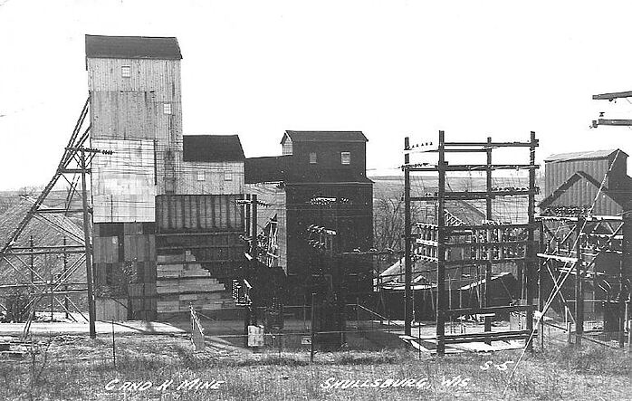
Calumet Mine (Calumet and Hecla Mine; C&H Mine; Shullsburg Mine; Eagle Picher), Shullsburg area, Lafayette County, Wisconsin, USAi
| Regional Level Types | |
|---|---|
| Calumet Mine (Calumet and Hecla Mine; C&H Mine; Shullsburg Mine; Eagle Picher) | Mine |
| Shullsburg area | Mining Area |
| Lafayette County | County |
| Wisconsin | State |
| USA | Country |
Calumet Mine (Calumet and Hecla Mine; C&H Mine; Shullsburg Mine; Eagle Picher), Shullsburg area, Upper Mississippi Valley Zinc-Lead District, USA
This page is currently not sponsored. Click here to sponsor this page.


Latitude & Longitude (WGS84):
42° 34' North , 90° 14' West
Latitude & Longitude (decimal):
Type:
Köppen climate type:
Nearest Settlements:
| Place | Population | Distance |
|---|---|---|
| Shullsburg | 1,210 (2017) | 0.8km |
| Scales Mound | 378 (2017) | 10.2km |
| Benton | 964 (2017) | 12.1km |
| Apple River | 356 (2017) | 13.0km |
| Darlington | 2,405 (2017) | 16.0km |
Nearest Clubs:
Local clubs are the best way to get access to collecting localities
Local clubs are the best way to get access to collecting localities
| Club | Location | Distance |
|---|---|---|
| Badger Lapidary & Geological Society, Inc. | Monroe, Wisconsin | 49km |
This important and productive zinc-lead deposit (section 22 T.1N. R.2E.) was discovered in 1947 and worked first 1949. It was last worked by Eagle-Picher Industries closing in October of 1979. Ore was mostly in pitch and flat structures in brecciated Ordovician carbonate rocks of the Platteville, Decorah and Galena Formations. There were 5 distinct ore bodies, the largest termed the North Hayden and South Hayden deposits. This was the last mine to operate in the Upper Mississippi Valley zinc-lead district after over 150 years of continuous mining activity.
Select Mineral List Type
Standard Detailed Gallery Strunz Chemical ElementsDetailed Mineral List:
| ⓘ Baryte Formula: BaSO4 |
| ✪ Calcite Formula: CaCO3 Description: Large complex crystals, sometimes sceptered. |
| ⓘ Dolomite Formula: CaMg(CO3)2 |
| ⓘ Galena Formula: PbS |
| ⓘ Marcasite Formula: FeS2 |
| ⓘ Millerite Formula: NiS |
| ⓘ Pyrite Formula: FeS2 |
| ⓘ Quartz Formula: SiO2 |
| ⓘ Sphalerite Formula: ZnS |

List of minerals arranged by Strunz 10th Edition classification
| Group 2 - Sulphides and Sulfosalts | |||
|---|---|---|---|
| ⓘ | Sphalerite | 2.CB.05a | ZnS |
| ⓘ | Millerite | 2.CC.20 | NiS |
| ⓘ | Galena | 2.CD.10 | PbS |
| ⓘ | Pyrite | 2.EB.05a | FeS2 |
| ⓘ | Marcasite | 2.EB.10a | FeS2 |
| Group 4 - Oxides and Hydroxides | |||
| ⓘ | Quartz | 4.DA.05 | SiO2 |
| Group 5 - Nitrates and Carbonates | |||
| ⓘ | Calcite | 5.AB.05 | CaCO3 |
| ⓘ | Dolomite | 5.AB.10 | CaMg(CO3)2 |
| Group 7 - Sulphates, Chromates, Molybdates and Tungstates | |||
| ⓘ | Baryte | 7.AD.35 | BaSO4 |
List of minerals for each chemical element
| C | Carbon | |
|---|---|---|
| C | ⓘ Calcite | CaCO3 |
| C | ⓘ Dolomite | CaMg(CO3)2 |
| O | Oxygen | |
| O | ⓘ Baryte | BaSO4 |
| O | ⓘ Calcite | CaCO3 |
| O | ⓘ Dolomite | CaMg(CO3)2 |
| O | ⓘ Quartz | SiO2 |
| Mg | Magnesium | |
| Mg | ⓘ Dolomite | CaMg(CO3)2 |
| Si | Silicon | |
| Si | ⓘ Quartz | SiO2 |
| S | Sulfur | |
| S | ⓘ Baryte | BaSO4 |
| S | ⓘ Galena | PbS |
| S | ⓘ Marcasite | FeS2 |
| S | ⓘ Millerite | NiS |
| S | ⓘ Pyrite | FeS2 |
| S | ⓘ Sphalerite | ZnS |
| Ca | Calcium | |
| Ca | ⓘ Calcite | CaCO3 |
| Ca | ⓘ Dolomite | CaMg(CO3)2 |
| Fe | Iron | |
| Fe | ⓘ Marcasite | FeS2 |
| Fe | ⓘ Pyrite | FeS2 |
| Ni | Nickel | |
| Ni | ⓘ Millerite | NiS |
| Zn | Zinc | |
| Zn | ⓘ Sphalerite | ZnS |
| Ba | Barium | |
| Ba | ⓘ Baryte | BaSO4 |
| Pb | Lead | |
| Pb | ⓘ Galena | PbS |
Other Regions, Features and Areas containing this locality
North AmericaContinent
North America PlateTectonic Plate
- Great Plains DomainDomain
- Mazatzal TerraneVolcanic Arc
USA
- Upper Mississippi Valley Zinc-Lead DistrictMining District
This page contains all mineral locality references listed on mindat.org. This does not claim to be a complete list. If you know of more minerals from this site, please register so you can add to our database. This locality information is for reference purposes only. You should never attempt to
visit any sites listed in mindat.org without first ensuring that you have the permission of the land and/or mineral rights holders
for access and that you are aware of all safety precautions necessary.

Calumet Mine, Shullsburg area, Lafayette County, Wisconsin, USA