Log In


Camporanda, Sillano, Garfagnana, Lucca Province, Tuscany, Italyi
| Regional Level Types | |
|---|---|
| Camporanda | - not defined - |
| Sillano | - not defined - |
| Garfagnana | - not defined - |
| Lucca Province | Province |
| Tuscany | Region |
| Italy | Country |
This page is currently not sponsored. Click here to sponsor this page.


Latitude & Longitude (WGS84):
44° 14' 22'' North , 10° 20' 9'' East
Latitude & Longitude (decimal):
Köppen climate type:
Nearest Settlements:
| Place | Population | Distance |
|---|---|---|
| Villa | 109 (2016) | 0.7km |
| Sillano | 352 (2016) | 3.3km |
| Sant'Anastasio | 147 (2014) | 6.0km |
| Colognola | 124 (2014) | 6.7km |
| San Donnino | 168 (2014) | 6.8km |
Name(s) in local language(s):
Camporanda, Sillano, Garfagnana, Lucca, Toscana, Italia
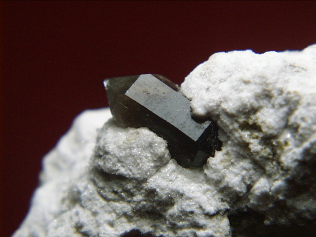
In this small area of the northern Apennines, there is an occurrence of Triassic evaporites in a tectonic window. In these rocks represented by evaporitic limestones locally known as "calcare cavernoso" there are also occurrences of anhydrite in which black quartz, pyrite, hematite are found. In some fractures of "calcare cavernoso" beautiful gypsum crystals have been found.
Select Mineral List Type
Standard Detailed Gallery Strunz Chemical ElementsDetailed Mineral List:
| ⓘ Anhydrite Formula: CaSO4 |
| ⓘ Gypsum Formula: CaSO4 · 2H2O |
| ⓘ Hematite Formula: Fe2O3 |
| ⓘ 'Petroleum' |
| ⓘ 'Petroleum var. Bitumen' |
| ⓘ Pyrite Formula: FeS2 |
| ⓘ Quartz Formula: SiO2 |
| ⓘ Formula: SiO2 Description: Black and brown crystals found at this locality are authigenic quartz crystals colored by inclusions. They are not smoky quartz. References: |

List of minerals arranged by Strunz 10th Edition classification
| Group 2 - Sulphides and Sulfosalts | |||
|---|---|---|---|
| ⓘ | Pyrite | 2.EB.05a | FeS2 |
| Group 4 - Oxides and Hydroxides | |||
| ⓘ | Hematite | 4.CB.05 | Fe2O3 |
| ⓘ | Quartz | 4.DA.05 | SiO2 |
| ⓘ | var. Smoky Quartz ? | 4.DA.05 | SiO2 |
| Group 7 - Sulphates, Chromates, Molybdates and Tungstates | |||
| ⓘ | Anhydrite | 7.AD.30 | CaSO4 |
| ⓘ | Gypsum | 7.CD.40 | CaSO4 · 2H2O |
| Unclassified | |||
| ⓘ | 'Petroleum var. Bitumen' | - | |
| ⓘ | '' | - | |
List of minerals for each chemical element
| H | Hydrogen | |
|---|---|---|
| H | ⓘ Gypsum | CaSO4 · 2H2O |
| O | Oxygen | |
| O | ⓘ Anhydrite | CaSO4 |
| O | ⓘ Gypsum | CaSO4 · 2H2O |
| O | ⓘ Hematite | Fe2O3 |
| O | ⓘ Quartz | SiO2 |
| O | ⓘ Quartz var. Smoky Quartz | SiO2 |
| Si | Silicon | |
| Si | ⓘ Quartz | SiO2 |
| Si | ⓘ Quartz var. Smoky Quartz | SiO2 |
| S | Sulfur | |
| S | ⓘ Anhydrite | CaSO4 |
| S | ⓘ Gypsum | CaSO4 · 2H2O |
| S | ⓘ Pyrite | FeS2 |
| Ca | Calcium | |
| Ca | ⓘ Anhydrite | CaSO4 |
| Ca | ⓘ Gypsum | CaSO4 · 2H2O |
| Fe | Iron | |
| Fe | ⓘ Hematite | Fe2O3 |
| Fe | ⓘ Pyrite | FeS2 |
Other Regions, Features and Areas containing this locality
Eurasian PlateTectonic Plate
- Apennine OrogenAccretionary Complex
EuropeContinent
Italy
- Tuscany
- Lucca Province
This page contains all mineral locality references listed on mindat.org. This does not claim to be a complete list. If you know of more minerals from this site, please register so you can add to our database. This locality information is for reference purposes only. You should never attempt to
visit any sites listed in mindat.org without first ensuring that you have the permission of the land and/or mineral rights holders
for access and that you are aware of all safety precautions necessary.

Camporanda, Sillano, Garfagnana, Lucca Province, Tuscany, Italy