Log In


Saunders Creek, Alice Downs Station, Halls Creek Shire, Western Australia, Australiai
| Regional Level Types | |
|---|---|
| Saunders Creek | Creek |
| Alice Downs Station | - not defined - |
| Halls Creek Shire | Shire |
| Western Australia | State |
| Australia | Country |
This page is currently not sponsored. Click here to sponsor this page.
Latitude & Longitude (WGS84):
17° 57' 7'' South , 128° 2' 39'' East
Latitude & Longitude (decimal):
Type:
Köppen climate type:
Nearest Settlements:
| Place | Population | Distance |
|---|---|---|
| Halls Creek | 1,209 (2012) | 50.1km |
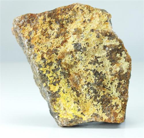
Uranium prospect. Variable descriptions have been found for the prospect's mineralogy. The Saunders Creek prospect is radioactive quartz pebble conglomerate bands in less radioactive quartz greywacke, and quartz sandstone, containing magnetite and rutile. It outcrops on the north-west shoulder of an overturned closed anticline. The source indicates uraninite is the main ore mineral, although the picture on Mindat would indicate carnotite is also found. It is also said thorogummite as sedimentary concentrations provides the radioactivity.
The prospect was discovered late 1954 by prospectors working for the United Uranium NL, but little exploration took place until 1957. Early drilling produced dis-appointing results, uranium values low, and the prospect was abandoned.
Map denotes the creek itself. Location of prospect needs confirmation.
Select Mineral List Type
Standard Detailed Gallery Strunz Chemical ElementsMineral List
5 valid minerals.
Rock Types Recorded
Note: data is currently VERY limited. Please bear with us while we work towards adding this information!
Select Rock List Type
Alphabetical List Tree DiagramDetailed Mineral List:
| ⓘ Carnotite Formula: K2(UO2)2(VO4)2 · 3H2O References: |
| ⓘ Magnetite Formula: Fe2+Fe3+2O4 |
| ⓘ Quartz Formula: SiO2 |
| ⓘ Rutile Formula: TiO2 |
| ⓘ Thorite var. Thorogummite Formula: (Th,U)(SiO4)1-x(OH)4x |
| ⓘ Uraninite Formula: UO2 |
Gallery:
List of minerals arranged by Strunz 10th Edition classification
| Group 4 - Oxides and Hydroxides | |||
|---|---|---|---|
| ⓘ | Magnetite | 4.BB.05 | Fe2+Fe3+2O4 |
| ⓘ | Quartz | 4.DA.05 | SiO2 |
| ⓘ | Rutile | 4.DB.05 | TiO2 |
| ⓘ | Uraninite | 4.DL.05 | UO2 |
| ⓘ | Carnotite | 4.HB.05 | K2(UO2)2(VO4)2 · 3H2O |
| Group 9 - Silicates | |||
| ⓘ | Thorite var. Thorogummite | 9.AD.30 | (Th,U)(SiO4)1-x(OH)4x |
List of minerals for each chemical element
| H | Hydrogen | |
|---|---|---|
| H | ⓘ Carnotite | K2(UO2)2(VO4)2 · 3H2O |
| H | ⓘ Thorite var. Thorogummite | (Th,U)(SiO4)1-x(OH)4x |
| O | Oxygen | |
| O | ⓘ Carnotite | K2(UO2)2(VO4)2 · 3H2O |
| O | ⓘ Magnetite | Fe2+Fe23+O4 |
| O | ⓘ Quartz | SiO2 |
| O | ⓘ Rutile | TiO2 |
| O | ⓘ Thorite var. Thorogummite | (Th,U)(SiO4)1-x(OH)4x |
| O | ⓘ Uraninite | UO2 |
| Si | Silicon | |
| Si | ⓘ Quartz | SiO2 |
| Si | ⓘ Thorite var. Thorogummite | (Th,U)(SiO4)1-x(OH)4x |
| K | Potassium | |
| K | ⓘ Carnotite | K2(UO2)2(VO4)2 · 3H2O |
| Ti | Titanium | |
| Ti | ⓘ Rutile | TiO2 |
| V | Vanadium | |
| V | ⓘ Carnotite | K2(UO2)2(VO4)2 · 3H2O |
| Fe | Iron | |
| Fe | ⓘ Magnetite | Fe2+Fe23+O4 |
| Th | Thorium | |
| Th | ⓘ Thorite var. Thorogummite | (Th,U)(SiO4)1-x(OH)4x |
| U | Uranium | |
| U | ⓘ Carnotite | K2(UO2)2(VO4)2 · 3H2O |
| U | ⓘ Thorite var. Thorogummite | (Th,U)(SiO4)1-x(OH)4x |
| U | ⓘ Uraninite | UO2 |
Other Regions, Features and Areas containing this locality
Australia
- Halls Creek OrogenOrogen
- Lamboo ProvinceGeologic Province
- North Australian ElementCraton
- Northern Territory
- Kalkarindji Igneous ProvinceGeologic Province
Australian PlateTectonic Plate
- North Australian Craton
- Kimberley CratonShield
This page contains all mineral locality references listed on mindat.org. This does not claim to be a complete list. If you know of more minerals from this site, please register so you can add to our database. This locality information is for reference purposes only. You should never attempt to
visit any sites listed in mindat.org without first ensuring that you have the permission of the land and/or mineral rights holders
for access and that you are aware of all safety precautions necessary.

Saunders Creek, Alice Downs Station, Halls Creek Shire, Western Australia, Australia