
Clip Mine, Clip, Hidden Valley, Silver Mining District, La Paz County, Arizona, USAi
| Regional Level Types | |
|---|---|
| Clip Mine | Mine |
| Clip | Unincorporated Area |
| Hidden Valley | Valley |
| Silver Mining District | Mining District |
| La Paz County | County |
| Arizona | State |
| USA | Country |
This page is currently not sponsored. Click here to sponsor this page.


Latitude & Longitude (WGS84):
33° 8' 12'' North , 114° 34' 54'' West
Latitude & Longitude (decimal):
Type:
Köppen climate type:
Nearest Settlements:
| Place | Population | Distance |
|---|---|---|
| Cibola | 250 (2011) | 21.4km |
| Palo Verde | 171 (2011) | 35.7km |
| Ripley | 692 (2011) | 43.7km |
| Winterhaven | 394 (2011) | 44.4km |
| Buckshot | 153 (2017) | 45.0km |
Other/historical names associated with this locality:
Silver Clip Mine; Blaine Mine; Silver Mines Consolidated Mine
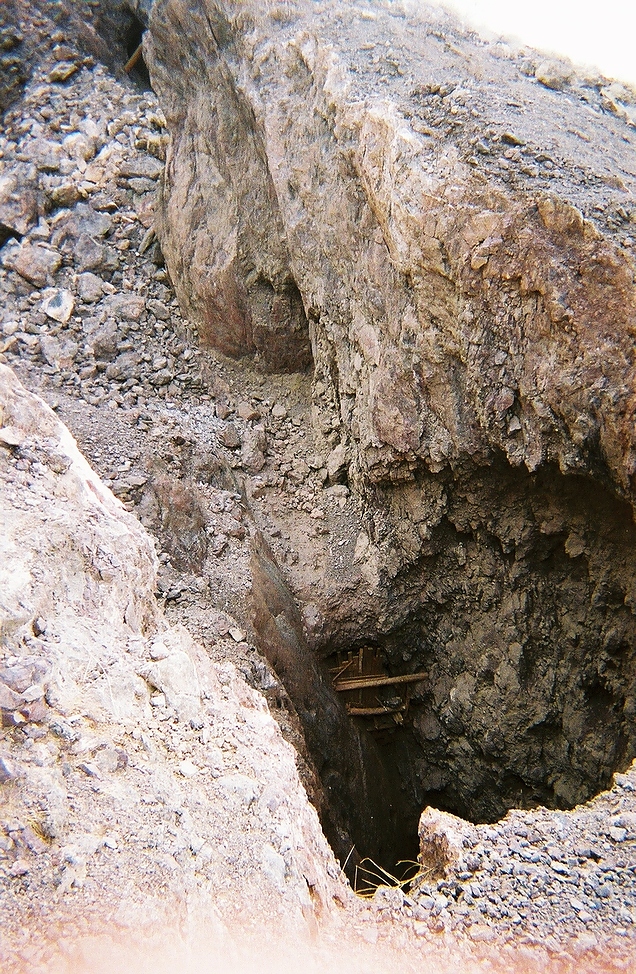
A former underground Pb-Ag-V-Fe-Mn-Sr-Baryte-Fluorspar-Cu (Cl-Br) mine located in the center of sec. 25, T3S, R23W, at the former mining town of Clip, 5 miles North of the former mining town of Silent, and 28 miles N of Yuma, on BLM-administered land. Owned at times, or in part, by Jas. G. Blaine; Messrs. Hubbard & Bowers (1883-April 1887); Messrs. Thompson, Shiner, Fields & Bates (circa 1925); Silver Mines Consolidated Co. (circa 1925); and the United Silver Mines Co. of Yuma (circa 1933).
Mineralization is a linear ore body with argentiferous, oxidized lead minerals with silver chloride and bromide, vanadinite, and some malachite in a gangue of ferruginous and manganiferous calcite, quartz, fluorite, barite, pyrolusite, iron oxides, celestine (?), gouge and brecciated wall rock, in a lensing vein in a fault zone cutting Tertiary andesitic to dacitic flows, tuffs and breccias. The ore zone is 228.6 meters long and 2.44 meters wide, with a depth to bottom of 36.58 meters, striking N30E, and dipping 70W. The beds, which generally dip at low angles, are extensively shattered in several directions. The most extensive fissuring trends N25E, with steep westward dip, and another prominent system strikes northward, with steep eastward dip. Many faults of undetermined throw strike NNE, N, and NW, with westward dips. Unspecified lead oxide also occurs. The vein and fault zone strike from N.30ºE. to N.10ºW. and dips from 60º to 70ºW. The vein is traceable for more than 750 feet. There is deep wall rock alteration to chlorite, limonite, and calcite as well as silicification and carbonitization. At the 120 foot level the ore shoots terminate or pinchout. Transverse faults increased ore values. Mineralization is along a fault zone. Ore reportedly ran 20 to 140 oz. Ag/T with very minor gold.
Lava flows, tuffs & breccias, mainly of andesitic composition, form sharp, Northward-trending ridges.
Workings included an adit and shaft(s) with stoping to the surface. There are 5 levels of drifts at approximate 40 foot intervals. It was mined mainly in 1883 to 1887 and to a lesser degree in 1925 through 1929. The total estimated and reported production would be some 25,000 tons of ore averaging about 46 oz. Ag/T. Silver produced was more than $1,000,000 (period values) and an additional 7,000 oz. Ag (1928-1929). No lead recovery reported. By 1883 a 10-stamp mill was erected at the Colorado River; a 100 ton cyanide plant was installed in 1927.
Select Mineral List Type
Standard Detailed Gallery Strunz Chemical ElementsCommodity List
This is a list of exploitable or exploited mineral commodities recorded at this locality.Mineral List
13 valid minerals.
Detailed Mineral List:
| ⓘ Baryte Formula: BaSO4 Description: Crystalline masses & thin blades cutting fluorite & quartz. |
| ⓘ Calcite Formula: CaCO3 Description: Contains considerable Mn & Fe, coarsely crystalline. |
| ⓘ Calcite var. Manganese-bearing Calcite Formula: (Ca,Mn)CO3 |
| ⓘ Celestine Formula: SrSO4 Description: Doubtful in mind of contributor - no celestine found recently or recorded in recent literature. Probably sprays of acicular, colorless willemite crystals (?). |
| ⓘ Cerussite Formula: PbCO3 Description: Small, irregular masses. |
| ⓘ Chlorargyrite Formula: AgCl Description: Principal silver mineral as small, irregular masses in oxidized ore. References: |
| ⓘ 'Chlorite Group' Description: Small, irregular masses. |
| ⓘ Dumortierite Formula: Al(Al2O)(Al2O)2(SiO4)3(BO3) |
| ⓘ Fluorite Formula: CaF2 Description: Visibly crystalline; generally as dense bands that coat quartz & is coated by white calite. |
| ⓘ Hematite Formula: Fe2O3 Description: Occupies cavities, fissures & vugs. |
| ⓘ Kyanite Formula: Al2(SiO4)O |
| ⓘ 'Limonite' Description: Occupies cavities, fissures & vugs. |
| ⓘ Malachite Formula: Cu2(CO3)(OH)2 |
| ⓘ Pyrolusite Formula: Mn4+O2 Description: Occupies cavities, fissures & vugs. |
| ⓘ Quartz Formula: SiO2 Description: Finely crystalline, banded to vuggy masses. |
| ⓘ Vanadinite Formula: Pb5(VO4)3Cl Description: Small, irregular masses and fine crystal aggregates. References: |
Gallery:
List of minerals arranged by Strunz 10th Edition classification
| Group 3 - Halides | |||
|---|---|---|---|
| ⓘ | Chlorargyrite | 3.AA.15 | AgCl |
| ⓘ | Fluorite | 3.AB.25 | CaF2 |
| Group 4 - Oxides and Hydroxides | |||
| ⓘ | Hematite | 4.CB.05 | Fe2O3 |
| ⓘ | Quartz | 4.DA.05 | SiO2 |
| ⓘ | Pyrolusite | 4.DB.05 | Mn4+O2 |
| Group 5 - Nitrates and Carbonates | |||
| ⓘ | Calcite | 5.AB.05 | CaCO3 |
| ⓘ | var. Manganese-bearing Calcite | 5.AB.05 | (Ca,Mn)CO3 |
| ⓘ | Cerussite | 5.AB.15 | PbCO3 |
| ⓘ | Malachite | 5.BA.10 | Cu2(CO3)(OH)2 |
| Group 7 - Sulphates, Chromates, Molybdates and Tungstates | |||
| ⓘ | Baryte | 7.AD.35 | BaSO4 |
| ⓘ | Celestine | 7.AD.35 | SrSO4 |
| Group 8 - Phosphates, Arsenates and Vanadates | |||
| ⓘ | Vanadinite | 8.BN.05 | Pb5(VO4)3Cl |
| Group 9 - Silicates | |||
| ⓘ | Kyanite | 9.AF.15 | Al2(SiO4)O |
| ⓘ | Dumortierite | 9.AJ.10 | Al(Al2O)(Al2O)2(SiO4)3(BO3) |
| Unclassified | |||
| ⓘ | 'Chlorite Group' | - | |
| ⓘ | 'Limonite' | - | |
List of minerals for each chemical element
Other Databases
| GeoNames ID: | 5290156 |
|---|---|
| Link to USGS MRDS: | 10027231 |
Other Regions, Features and Areas containing this locality
North AmericaContinent
- Sonoran DesertDesert
North America PlateTectonic Plate
- Basin and Range BasinsBasin
- Mojave DomainDomain
- Southern Basin and RangeWide Rift
USA
- Arizona
- La Paz County
- Trigo MountainsMountain Range
- La Paz County
This page contains all mineral locality references listed on mindat.org. This does not claim to be a complete list. If you know of more minerals from this site, please register so you can add to our database. This locality information is for reference purposes only. You should never attempt to
visit any sites listed in mindat.org without first ensuring that you have the permission of the land and/or mineral rights holders
for access and that you are aware of all safety precautions necessary.
References
Wilson, Eldred D. (1933) Geology and Mineral Deposits of Southern Yuma County, Arizona. University of Arizona Bulletin 134. Arizona Bureau of MinesPages 50, 53, 56, 57-59
Parker, Frank Z. (1966) The geology and mineral deposits of the Silver District, Trigo Mountains, Yuma County, Arizona. Masters, San Diego State College.

Clip Mine, Clip, Hidden Valley, Silver Mining District, La Paz County, Arizona, USA