Log In


Zehntausend Ritter Mine, Kippenhain Mine (Kippenhayn Mine), Schreckenberg, Frohnau, Annaberg-Buchholz, Erzgebirgskreis, Saxony, Germanyi
Zehntausend Ritter Mine, Kippenhain Mine (Kippenhayn Mine), Schreckenberg, Annaberg mining district, Saxony, Germany
This page is currently not sponsored. Click here to sponsor this page.


Latitude & Longitude (WGS84):
50° 35' 15'' North , 12° 59' 44'' East
Latitude & Longitude (decimal):
Type:
Mine (Abandoned) - last checked 2020
Köppen climate type:
Nearest Settlements:
| Place | Population | Distance |
|---|---|---|
| Annaberg-Buchholz | 23,092 (2015) | 1.2km |
| Wiesa | 3,811 (2018) | 2.9km |
| Schlettau | 2,733 (2015) | 4.4km |
| Tannenberg | 1,283 (2017) | 4.6km |
| Mildenau | 3,749 (2017) | 5.4km |
Other/historical names associated with this locality:
10000 Ritter Mine
Name(s) in local language(s):
Zehntausend Ritter Fundgrube (einschl. Zehntausend Ritter Hilfe Fundgrube), Kippenhain Fundgrube (Kippenhayn Fundgrube), Schreckenberg, Frohnau, Annaberg-Buchholz, Revier Annaberg, Erzgebirge, Sachsen, Deutschland
An old silver and cobalt mine, started in 1528 and worked intermittently until 1779, when it was included with the Kippenhain Mine.
The workings comprised the Zehntausend Ritter Rösche adit (Zehntausend Ritter Rösche Stolln) and the Zehntausend Ritter Gegentrum.
The mine includes the Zehntausend Ritter Hilfe Mine.
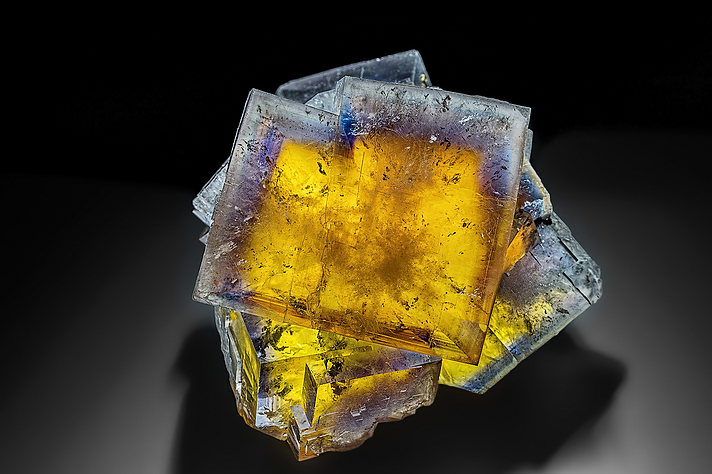
The fluorites marked with the location "10.000 Ritter Mine" all come from the outcrop (of the uranium ore mining of the SAG Wismut) of the "Bergmännish Glück Flacher" vein and not from the historical locality (https://www.mineralienatlas.de/?l=523).
Select Mineral List Type
Standard Detailed Gallery Strunz Chemical ElementsCommodity List
This is a list of exploitable or exploited mineral commodities recorded at this locality.Mineral List
4 valid minerals.
Detailed Mineral List:
| ⓘ Baryte Formula: BaSO4 References: |
| ⓘ Dolomite Formula: CaMg(CO3)2 References: |
| ⓘ Fluorite Formula: CaF2 References: |
| ⓘ Quartz Formula: SiO2 References: |

List of minerals arranged by Strunz 10th Edition classification
| Group 3 - Halides | |||
|---|---|---|---|
| ⓘ | Fluorite | 3.AB.25 | CaF2 |
| Group 4 - Oxides and Hydroxides | |||
| ⓘ | Quartz | 4.DA.05 | SiO2 |
| Group 5 - Nitrates and Carbonates | |||
| ⓘ | Dolomite | 5.AB.10 | CaMg(CO3)2 |
| Group 7 - Sulphates, Chromates, Molybdates and Tungstates | |||
| ⓘ | Baryte | 7.AD.35 | BaSO4 |
List of minerals for each chemical element
| C | Carbon | |
|---|---|---|
| C | ⓘ Dolomite | CaMg(CO3)2 |
| O | Oxygen | |
| O | ⓘ Baryte | BaSO4 |
| O | ⓘ Dolomite | CaMg(CO3)2 |
| O | ⓘ Quartz | SiO2 |
| F | Fluorine | |
| F | ⓘ Fluorite | CaF2 |
| Mg | Magnesium | |
| Mg | ⓘ Dolomite | CaMg(CO3)2 |
| Si | Silicon | |
| Si | ⓘ Quartz | SiO2 |
| S | Sulfur | |
| S | ⓘ Baryte | BaSO4 |
| Ca | Calcium | |
| Ca | ⓘ Dolomite | CaMg(CO3)2 |
| Ca | ⓘ Fluorite | CaF2 |
| Ba | Barium | |
| Ba | ⓘ Baryte | BaSO4 |
Other Regions, Features and Areas containing this locality
Eurasian PlateTectonic Plate
- Saxo-Thuringian BeltOrogenic Belt
EuropeContinent
- Bohemian MassifMassif
- Ore MountainsMountain Range
Germany
- Saxony
- Annaberg mining districtMining District
This page contains all mineral locality references listed on mindat.org. This does not claim to be a complete list. If you know of more minerals from this site, please register so you can add to our database. This locality information is for reference purposes only. You should never attempt to
visit any sites listed in mindat.org without first ensuring that you have the permission of the land and/or mineral rights holders
for access and that you are aware of all safety precautions necessary.

Zehntausend Ritter Mine, Kippenhain Mine, Schreckenberg, Frohnau, Annaberg-Buchholz, Erzgebirgskreis, Saxony, Germany