Log In


Ashfall Fossil Beds State Historical Park, Antelope County, Nebraska, USAi
| Regional Level Types | |
|---|---|
| Ashfall Fossil Beds State Historical Park | State Park |
| Antelope County | County |
| Nebraska | State |
| USA | Country |
This page is currently not sponsored. Click here to sponsor this page.

Type:
State Park - last checked 2020
Deposit first discovered:
1971
Age:
23.03 to 5.332 Ma
Geologic Time:
Reference for age:
Ashfall Fossil Beds State Historical Park website
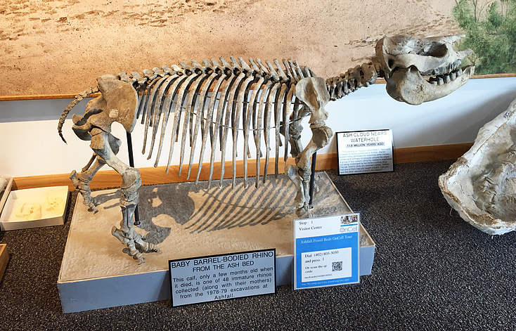
The Ashfall deposit preserves the fossilized remains of ancient animals that perished in a dense volcanic ash fall which occurred during the late Miocene, approximately 12 million years ago; the animals had come to a waterhole seeking relief. The fall of ash drifted downwind from the Bruneau-Jarbidge supervolcano eruption (in present-day Yellowstone Park, Idaho), nearly 1,000 miles (1,600 km) west of the Ashfall site. (Source: Wikipedia). Over 200 fossil mammal skeletons have been recovered from the ashbed at the site, including 5 genera of horses, 3 genera of camels, 3 genera of dogs, 1 genus of rhinoceros, and a genus of a saber-toothed deer. Additionally, skeletons from 3 species of birds and 2 species of turtles, and other fossils have been found. Many skeletons have been recovered fully articulated (Source: Wikipedia)
The site was discovered by University of Nebraska paleontologist Michael Voorheis in 1971. State Historical Park opened in 1991. The site was declared a National Natural Landmark in 2006. The park's Hubbard Rhino Barn opened in 2009. The 17,500-square-foot (1,630 m2) pavilion lets visitors observe as paleontologists carry out excavations of new discoveries exactly where the fossilized remains lie preserved. Walkways give visitors a view of paleontologists at work during the summer field season. An attached museum includes mounted skeletons and displays.
Ashfall Fossil Beds is located 2 miles west and 6 miles north of Royal, Nebraska, at 86930 517th Ave., Royal, NE 68773.
List of minerals for each chemical element
Fossils
This region is too big or complex to display the fossil list, try looking at smaller subregions.Other Databases
| Wikipedia: | https://en.wikipedia.org/wiki/Ashfall_Fossil_Beds |
|---|---|
| Wikidata ID: | Q4804942 |
| GeoNames ID: | 5063227 |
This page contains all mineral locality references listed on mindat.org. This does not claim to be a complete list. If you know of more minerals from this site, please register so you can add to our database. This locality information is for reference purposes only. You should never attempt to
visit any sites listed in mindat.org without first ensuring that you have the permission of the land and/or mineral rights holders
for access and that you are aware of all safety precautions necessary.

Ashfall Fossil Beds State Historical Park, Antelope County, Nebraska, USA