Log In


Great Wheal Busy (Chacewater Mine), Chacewater, Cornwall, England, UKi
| Regional Level Types | |
|---|---|
| Great Wheal Busy (Chacewater Mine) | Mine (Abandoned) |
| Chacewater | Civil Parish |
| Cornwall | County |
| England | Constituent Country |
| UK | Country |
This page is currently not sponsored. Click here to sponsor this page.


Latitude & Longitude (WGS84):
50° 15' 29'' North , 5° 10' 26'' West
Latitude & Longitude (decimal):
UK National Grid Reference:
SW738447
Type:
Mine (Abandoned) - last checked 2020
Köppen climate type:
Nearest Settlements:
| Place | Population | Distance |
|---|---|---|
| Chacewater | 1,226 (2017) | 1.2km |
| St. Day | 700 (2011) | 2.2km |
| Mount Hawke | 1,511 (2017) | 3.6km |
| Redruth | 42,690 (2017) | 4.5km |
| North Country | 773 (2017) | 4.6km |
Great Wheal Busy was working a series of ENE-trending, flat dipping lodes hosted in metamorphosed killas. The sett is traversed by an elvan dyke, which was highly impregnated with sulphide ores in some places. The main ore bodies were those on Winter's lode and Chacewater lode, located in the hanging wall and footwall, respectively, of the elvan, and Hodge's lode, located in the footwall of Chacewater lode. They were worked from shafts arranged in two lines about 100 yards apart, which can still be identified in the field. Wheal Vor lode, south of the elvan, was worked from another group of shafts close to the Redruth-Chacewater road. The other lodes, on which only little work was done, are located north of the elvan and trend roughly parallel to it.
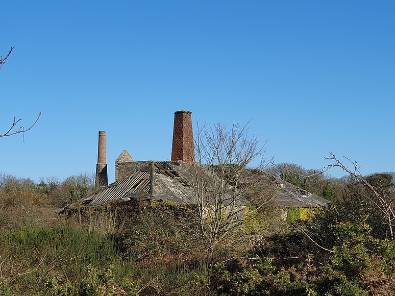
For some time, the mine was operated as Great Wheal Busy United Mine and included Hallenbeagle Mine, Great North Downs Mine, and other small mines in the area. It was already active in 1718, and was first worked for copper, but there are no records of its early production. From 1815 to 1870, it produced large quantities of copper, the bulk of which was raised before 1856 when the mine was 100 fms below Deep Adit level. In that year, the workings were sunk another 40 fms, and tin and copper ores were produced during the next ten years. In later years, it was worked mainly for arsenic. In the early 20th century, the dumps were worked over for arsenic and wolfram. Numerous shafts and spoil heaps are located in a large area north of the Redruth-Chacewater road. There are also remains of a calciner, some engine houses and a smithy.
Select Mineral List Type
Standard Detailed Gallery Strunz Chemical ElementsCommodity List
This is a list of exploitable or exploited mineral commodities recorded at this locality.Mineral List
13 valid minerals.
Detailed Mineral List:
| ⓘ Anatase Formula: TiO2 Habit: Forms deep blue bipyramidal and tabular crystals on a quartz matrix associated with chorite. References: |
| ⓘ 'Apatite' Formula: Ca5(PO4)3(Cl/F/OH) Description: Accessory mineral in country rock adjacent to the lodes. |
| ⓘ Arsenopyrite Formula: FeAsS References: |
| ⓘ Cassiterite Formula: SnO2 References: |
| ⓘ Chalcopyrite Formula: CuFeS2 References: |
| ⓘ 'Chlorite Group' |
| ⓘ Cuprite Formula: Cu2O References: Griffiths, Dave (n.d.) Personal communication (1).Identified by Dave Griffiths: Visual Identification |
| ⓘ Fluorite Formula: CaF2 |
| ⓘ Galena Formula: PbS |
| ⓘ Muscovite Formula: KAl2(AlSi3O10)(OH)2 |
| ⓘ Pyrite Formula: FeS2 |
| ⓘ Quartz Formula: SiO2 |
| ⓘ Sphalerite Formula: ZnS |
| ⓘ Titanite Formula: CaTi(SiO4)O Description: Accessory mineral in country rock adjacent to the lodes. |
| ⓘ 'Tourmaline' Formula: AD3G6 (T6O18)(BO3)3X3Z |
| ⓘ 'Wolframite Group' References: |
| ⓘ Zircon Formula: Zr(SiO4) Description: Accessory mineral in country rock adjacent to the lodes. |

List of minerals arranged by Strunz 10th Edition classification
| Group 2 - Sulphides and Sulfosalts | |||
|---|---|---|---|
| ⓘ | Sphalerite | 2.CB.05a | ZnS |
| ⓘ | Chalcopyrite | 2.CB.10a | CuFeS2 |
| ⓘ | Galena | 2.CD.10 | PbS |
| ⓘ | Pyrite | 2.EB.05a | FeS2 |
| ⓘ | Arsenopyrite | 2.EB.20 | FeAsS |
| Group 3 - Halides | |||
| ⓘ | Fluorite | 3.AB.25 | CaF2 |
| Group 4 - Oxides and Hydroxides | |||
| ⓘ | Cuprite | 4.AA.10 | Cu2O |
| ⓘ | Quartz | 4.DA.05 | SiO2 |
| ⓘ | Cassiterite | 4.DB.05 | SnO2 |
| ⓘ | 'Wolframite Group' | 4.DB.30 va | |
| ⓘ | Anatase | 4.DD.05 | TiO2 |
| Group 9 - Silicates | |||
| ⓘ | Zircon | 9.AD.30 | Zr(SiO4) |
| ⓘ | Titanite | 9.AG.15 | CaTi(SiO4)O |
| ⓘ | Muscovite | 9.EC.15 | KAl2(AlSi3O10)(OH)2 |
| Unclassified | |||
| ⓘ | 'Chlorite Group' | - | |
| ⓘ | 'Tourmaline' | - | AD3G6 (T6O18)(BO3)3X3Z |
| ⓘ | 'Apatite' | - | Ca5(PO4)3(Cl/F/OH) |
List of minerals for each chemical element
| H | Hydrogen | |
|---|---|---|
| H | ⓘ Muscovite | KAl2(AlSi3O10)(OH)2 |
| H | ⓘ Apatite | Ca5(PO4)3(Cl/F/OH) |
| B | Boron | |
| B | ⓘ Tourmaline | AD3G6 (T6O18)(BO3)3X3Z |
| O | Oxygen | |
| O | ⓘ Anatase | TiO2 |
| O | ⓘ Cassiterite | SnO2 |
| O | ⓘ Cuprite | Cu2O |
| O | ⓘ Muscovite | KAl2(AlSi3O10)(OH)2 |
| O | ⓘ Quartz | SiO2 |
| O | ⓘ Titanite | CaTi(SiO4)O |
| O | ⓘ Tourmaline | AD3G6 (T6O18)(BO3)3X3Z |
| O | ⓘ Zircon | Zr(SiO4) |
| O | ⓘ Apatite | Ca5(PO4)3(Cl/F/OH) |
| F | Fluorine | |
| F | ⓘ Fluorite | CaF2 |
| F | ⓘ Apatite | Ca5(PO4)3(Cl/F/OH) |
| Al | Aluminium | |
| Al | ⓘ Muscovite | KAl2(AlSi3O10)(OH)2 |
| Si | Silicon | |
| Si | ⓘ Muscovite | KAl2(AlSi3O10)(OH)2 |
| Si | ⓘ Quartz | SiO2 |
| Si | ⓘ Titanite | CaTi(SiO4)O |
| Si | ⓘ Zircon | Zr(SiO4) |
| P | Phosphorus | |
| P | ⓘ Apatite | Ca5(PO4)3(Cl/F/OH) |
| S | Sulfur | |
| S | ⓘ Arsenopyrite | FeAsS |
| S | ⓘ Chalcopyrite | CuFeS2 |
| S | ⓘ Galena | PbS |
| S | ⓘ Pyrite | FeS2 |
| S | ⓘ Sphalerite | ZnS |
| Cl | Chlorine | |
| Cl | ⓘ Apatite | Ca5(PO4)3(Cl/F/OH) |
| K | Potassium | |
| K | ⓘ Muscovite | KAl2(AlSi3O10)(OH)2 |
| Ca | Calcium | |
| Ca | ⓘ Fluorite | CaF2 |
| Ca | ⓘ Titanite | CaTi(SiO4)O |
| Ca | ⓘ Apatite | Ca5(PO4)3(Cl/F/OH) |
| Ti | Titanium | |
| Ti | ⓘ Anatase | TiO2 |
| Ti | ⓘ Titanite | CaTi(SiO4)O |
| Fe | Iron | |
| Fe | ⓘ Arsenopyrite | FeAsS |
| Fe | ⓘ Chalcopyrite | CuFeS2 |
| Fe | ⓘ Pyrite | FeS2 |
| Cu | Copper | |
| Cu | ⓘ Chalcopyrite | CuFeS2 |
| Cu | ⓘ Cuprite | Cu2O |
| Zn | Zinc | |
| Zn | ⓘ Sphalerite | ZnS |
| As | Arsenic | |
| As | ⓘ Arsenopyrite | FeAsS |
| Zr | Zirconium | |
| Zr | ⓘ Zircon | Zr(SiO4) |
| Sn | Tin | |
| Sn | ⓘ Cassiterite | SnO2 |
| Pb | Lead | |
| Pb | ⓘ Galena | PbS |
Geochronology
| Geologic Time | Rocks, Minerals and Events | |||||||||||||||||||||
|---|---|---|---|---|---|---|---|---|---|---|---|---|---|---|---|---|---|---|---|---|---|---|
| Phanerozoic | ||||||||||||||||||||||
| Paleozoic | ||||||||||||||||||||||
| Permian | ||||||||||||||||||||||
| Guadalupian |
| |||||||||||||||||||||
| Cisuralian |
| |||||||||||||||||||||
Other Regions, Features and Areas containing this locality
British and Irish IslesGroup of Islands
Eurasian PlateTectonic Plate
- Rheno-Hercynian BeltOrogenic Belt
EuropeContinent
UK
- England
- Cornwall
- Camborne-Redruth and St Day Mining DistrictMining District
- Devon and Cornwall metalliferous mining districtMining District
- Cornwall
This page contains all mineral locality references listed on mindat.org. This does not claim to be a complete list. If you know of more minerals from this site, please register so you can add to our database. This locality information is for reference purposes only. You should never attempt to
visit any sites listed in mindat.org without first ensuring that you have the permission of the land and/or mineral rights holders
for access and that you are aware of all safety precautions necessary.

Great Wheal Busy, Chacewater, Cornwall, England, UK