
Soledad Mountain deposit, Soledad Mountain (Butte Mountain), Mojave, Mojave-Rosamond Mining District (Mojave Mining District), Kern County, California, USAi
This page is currently not sponsored. Click here to sponsor this page.

Latitude & Longitude (WGS84):
34° 59' 7'' North , 118° 11' 38'' West
Latitude & Longitude (decimal):
Type:
Köppen climate type:
Nearest Settlements:
| Place | Population | Distance |
|---|---|---|
| Mojave | 4,238 (2011) | 7.7km |
| Rosamond | 18,150 (2011) | 13.8km |
| California City | 13,277 (2017) | 24.5km |
| Edwards Air Force Base | 2,063 (2013) | 24.8km |
| Tehachapi | 13,021 (2017) | 28.4km |
Nearest Clubs:
Local clubs are the best way to get access to collecting localities
Local clubs are the best way to get access to collecting localities
| Club | Location | Distance |
|---|---|---|
| Tehachapi Valley Gem & Mineral Society | Tehachapi, California | 28km |
| Antelope Valley Gem and Mineral Club | Lancaster, California | 32km |
| Palmdale Gem & Mineral Club | Palmdale, California | 46km |
A Ag-Au-Cu-Pb-Sb deposit located in sections 5, 6, 7, 8 & 18, T10N, R12W, SBM, on and around Soledad Mountain, about 5 miles S of Mojave. It was discovered in 1894.
Although this property would be mined in the future for its gold, it is dominantly a silver deposit, with an overall silver:gold ratio of about 5:1 at the Golden Queen Mine (locally the ratio is up to about 25:1). The minor commodities listed have had negligible production. Ore grades along the quartz veins varied from tenths of ounces to ounces of gold and silver per ton of ore.
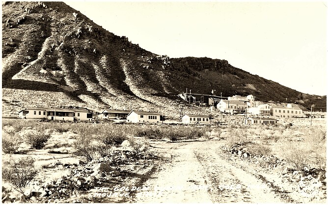
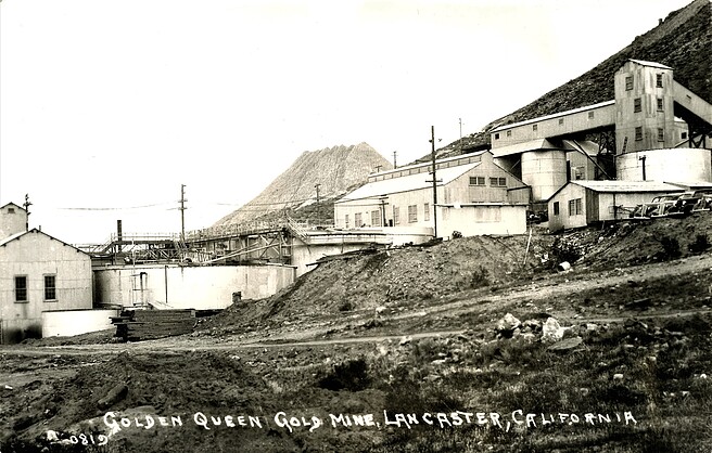
HISTORY AND STATUS: Soledad Mountain has been the most important gold-silver deposit in the Mojave Mining District. Discovery of gold in float at nearby Bowers (now Standard) Hill about two miles to the north in 1894, led to discovery and development of the Queen Esther Mine at Soledad Mountain in the same year. Underground mining expanded rapidly with discoveries of gold-silver mineralization along the Queen Esther, Karma, Echo, Elephant, and Gray Eagle veins. This first phase of mining ended about 1914, with about $5 million in gold and silver produced. Grubstaking by the Burton Brothers during the Depression-era 1930s led to renewed mining of Soledad Mountain deposit as well as neighboring deposits in the Mojave Mining District. This activity continued work on the previously discovered veins and resulted in new discoveries. In particular, discovery of the Silver Queen vein by George Holmes in 1933 significantly revived the entire Mojave Mining District. Much of the important parts of the Soledad Mountain deposit were consolidated in 1935 as the Golden Queen Mine under ownership of the Golden Queen Mining Company. The company conducted extensive exploration and development, including diamond drilling, until shut down in 1942 by the War Production Board during World War II. Increased mining costs prevented renewal of operations after World War II, with the mill dismantled in 1950 and remaining assets liquidated in 1954. In the early 1950s, a few lessees processed a minor amount of ore from the deposit. All mines were idle in 1958 except for minor work by lessees. In 1983, the Anaconda Mining Company (unpublished document) concluded from reconnaissance that it appeared unlikely that there was potential for a bulk-tonnage gold-silver deposit here. Golden Queen Mining Company, Ltd., the current operator of this idle property, assumed control in about 1985, but has not begun mining because of the low price for gold. The Golden Queen Project is expected to be economic at a price of $325 per ounce. In this project, the company proposes to develop an open-pit, heap-leach operation, which will be capable of mining 5.67 million metric tons per year over a mine-life of 11 years. In 1999, the company conducted extensive exploration including about 32,000 feet of drilling and surface sampling. To improve the economics of the project, it is proposed to sell waste rock from the mining operation as aggregate to surrounding markets, which can be reached via an adjacent freeway and railroad. As of 2001, the company had reportedly secured all permits, but was still waiting for improvement in the price of gold to commence mining. Past processing at a large mill operated by the Golden Queen Mining Company on the northwest side of Soledad Mountain included use of cyanide for vat leaching. Water for the mill was obtained from two nearby wells at depths between 200-300 feet. Several other cyanide mills were active on the north side of the mountain during the first phase of mining in the early 1900s. In early years, some of the mills used amalgamation. Reclamation has not taken place at the deposit because mining took place before requirement of reclamation by the State of California in the 1970s. Many dumps and tailings are present on the mountain, particularly on the northern flank. In addition, numerous shafts, tunnels, and daylighted stopes are still open.
ENVIRONMENT: Soledad Mountain is an approximately 6-square-mile rugged topographic prominence that rises above the flat alluvial plain of the westernmost Mojave Desert geomorphic province. It is the most conspicuous of many isolated hills and buttes that rise from this plain, which forms a triangular west-pointing wedge bordered by the Tehachapi Mountains on the north and the San Gabriel Mountains on the south. The mountain reaches an elevation of 4,190 feet from a base level of about 2,700 feet and is the eroded remnant of a complex of volcanic vents. Many dry washes and gullies cut the slopes of Soledad Mountain. The surrounding alluvial plain is typical of the Mojave Desert hydrographically in that washes are dry except during storms. Drainage is internal, with no significant channels in the immediate area around the mountain. Based on water well measurements, the water table is about 300 feet deep beneath the plain on the north side of Soledad Mountain, while it is about 100 feet deep on the south side. Vegetation is typical of the high desert of this latitude: sparse, characterized by creosote, burro weed, bunch grass, and scattered Joshua trees. Climate of this area is arid, with an average total precipitation of slightly less than 8 inches in nearby Lancaster. Temperatures reach freezing during the winter, but commonly rise to over 100 degrees Farenheit during the summer. Soledad Mountain itself is undeveloped except for the remnants of extensive mining activity over the last century. The surrounding plain has scattered residences, some of which are clustered. The small town of Mojave is less than 5 miles to the N. A major freeway (State Highway 14) and railroad run N-S on the east edge of the mountain.
MINERALIZATION: tHIS is a polymetallic precious and base metals deposit (Mineral occurrence model information: Model code: 151; USGS model code: 25d; Deposit model name: epithermal vein, Sado; Mark3 model number: 28). The deposit is hosted in Early Miocene quartz latite of the Bobtail Quartz Latite Member; Early Miocene rhyolite (pyroclastic) of the Gem Hill Formation; Early Miocene rhyolite (flows) of the Bobtail Quartz Latite Member; Early Miocene rhyolite (porphyritic) of the Bobtail Quartz Latite Member; and Early Miocene porphyry (rhyolite) of the Bobtail Quartz Latite Member. The deposit is generally tabular in form. Local alteration includes silicic; quartz advanced argillic; quartz, kaolinite, alunite oxidation; limonite. Associated rocks include Late Cretaceous quartz monzonite. Local rocks include Tertiary volcanic flow rocks, unit 16 (Northern Mojave Desert).
Controls for ore emplacement included faults that served as loci for deposition of ore. According to Julihn and Horton (1937), a felsite is the most favorable rock type for finding ore because its hard, brittle character allowed fractures to remain open for subsequent movement of hydrothermal fluids; no rhyolite tuff was known at the time to have been mined as ore.
GEOLOGIC STRUCTURES: Soledad Mountain is an eroded constructional volcanic edifice composed of a calc-alkaline suite of silicic domes, flows, and pyroclastic rock. The edifice was intruded into and built upon a plutonic basement. The Soledad Mountain deposit consists of many subparallel NW-trending fissure-filling quartz veins that cut this volcanic complex. The veins are exposed at the surface, which indicates shallow depth of formation. Descriptions of the textures of the quartz veins are scarce, but there are many references to brecciation and oxidation. A layer of silica (siliceous sinter?), interbedded with lacustrine deposits associated with the volcanic complex, was reported by McCusker (1982) to be on the eastern flank of the mountain. Hydrothermal alteration includes extensive silicification and local development of kaolinite and alunite. According to Julihn and Horton (1937), most of the values in the ore are derived from gold in exceedingly fine particles, together with silver sulfides (argentite) and silver chloride (cerargyrite), which likewise are seldom apparent; the ore commonly appears to be merely quartz or silicified country rock, which are often brecciated and recemented. Best ore typically occurred in the ?felsite? unit (Julihn and Horton, 1937), which may be equivalent to the aphyric rhyolite unit of McCusker (1982). The above evidence indicates that the deposit was formed under shallow epithermal conditions.
Regional geologic structures include the San Andreas Fault and the Garlock Fault. Local geologic structures include significant veins from E to W, including the Karma, Queen Esther, Silver Queen, Golden Queen, Starlight, Soledad Extension, Hope, Elephant, and Bobtail-Excelsior. These trend N10-40W and dip 60o or more to the NE or SW. Two other younger minor sets trend N50-80W and N-S.
INTRODUCTION: This part of California consists of a complex intersection of three geomorphic provinces: the Mojave Desert province forms a west-pointing wedge between the Sierra Nevada province on the north and the Transverse Ranges province on the south. Within this region of intersection are various precious-metal deposits, a few of which are considered significant. Most important is Soledad Mountain, which is situated within the Mojave Desert province.
REGIONAL SETTING: Several generations of geologic study have been applied to this region of California. Earlier work by Simpson (1934) and Dibblee (1963, 1967) established a regional framework of stratigraphy and structure upon which later, more detailed local studies have been conducted. One of these important local studies, which centered on the volcanic features of Soledad Mountain, is that of McCusker (1982) who mapped the mountain at a scale of 1:6,000. Other older technical papers also present information on the geology of the mountain (Bateson, 1907; Simpson, 1934; Julihn and Horton, 1937; Dibblee, 1963). On a broader scale, many papers have been published in the last 20 years that attempt to reconstruct this region's geologic history in the light of plate tectonics; among these are papers or volumes by Dickinson (1981, 1997), Burchfiel and others (1992), Dokka and Ross (1995), Atwater (1989), and Atwater and Stock (1998). Stratigraphy The rocks of the western part of the Mojave Desert province can be generalized as topographic ?islands,? or inliers, that are surrounded by plains of Quaternary alluvium. These inliers consist of Mesozoic plutonic basement with pendants of older metamorphic rock, which are overlain by an eroded Tertiary cover. The Mesozoic plutonic basement ranges in composition from quartz diorite to granite and is present beneath the alluvial plains. The Tertiary cover consists of volcanic and sedimentary rocks. Simpson (1934) originally mapped the Tertiary cover as the "Rosamond series," but Dibblee (1963, 1967) later remapped it as the "Tropico Group." Within the Tropico Group, Dibblee (1963, 1967) mapped a volcanic unit known as the Gem Hill Formation, which includes a sub-unit at Soledad Mountain called the Bobtail quartz latite member. Dibblee placed the pyroclastic phases at Soledad Mountain in the Gem Hill and the hypabyssal and lava phases in the Bobtail. Structure Although the basement complex is part of the Sierra Nevada plutonic arc, which was associated with subduction tectonics during the Mesozoic, it is regional tectonism during the Late Cenozoic that was important in the development of the ore deposit at Soledad Mountain. Tectonics of this region during the Late Cenozoic were first dominated by subduction of plates to the west of this region and then by subsequent movements along the northwest-trending right-lateral San Andreas Fault System, which progressively formed when the Farallon-Pacific spreading center collided with the subduction zone (Atwater, 1989). This tectonic activity was part of the larger interaction of the North American Plate, Pacific Plate, and intervening Farallon Plate (and its subsidiary plates, which formed upon breakup of the Farallon within subduction zones) as they collided along the west coast of North America. With shutting off of subduction along the coast and resultant development of a slab window inboard of the newly developed San Andreas transform boundary that replaced the trench, magma may have ascended from the mantle to fill the void between the transform fault system and the broken-off slab that was still descending to the east of the system. The volcanism at Soledad Mountain may have been a local expression of this process.
The western Mojave Desert is part of what is termed the "Mojave Desert block." the geologic history of this structural block, particularly the western part, is still controversial. The western area is considered by Dokka (1989) to be part of what he termed the Mojave Extensional Belt (MEB), an approximately E-W-trending zone that is inferred to underlie much of the western two-thirds of the Mojave Desert including Soledad Mountain. The westernmost part of the belt, which includes Soledad Mountain, was termed the Edwards Terrane by Dokka (1989). In this model, the upper and middle crust of the MEB was extended in early Miocene (24 to 21 Ma) by low- and high-angle normal faulting accompanied by intrusion and eruption of intermediate to silicic magmas (Dokka and others, 1998). According to Dokka and Ross (1995), the MEB was overprinted about 20-18 Ma by a zone of dextral shear known as the Trans-Mojave-Sierran shear zone. This zone produced clockwise vertical-axis rotation of both the western Mojave Desert and the southernmost Sierra Nevada. Dokka and Ross (1995) believed that interaction of the Pacific and North American plates during this period of time was directly responsible for regional extension in the western Mojave Desert. The interaction may have been highlighted by transtensional pulling away of the Pacific Plate from the North American Plate (Atwater, 1989) which caused the edge of the North American Plate to extensionally collapse, perhaps by gravitational failure. This inferred extensional activity between 24 and 18 Ma overlaps the known ages of all Cenozoic volcanic activity at Soledad Mountain as determined by McCusker (1982). Based on surface mapping and seismic-reflection surveys, Dokka (1989) concluded that the inliers discussed above are tilted upper-plate normal-fault blocks that are floored by detachment faults in the subsurface. The current orientation of structural features indicate that the extensional direction for the MEB is NE-SW; however, Dokka and Ross (1995) cited paleomagnetic evidence that suggests the western part of the Mojave Desert block may have been rotated clockwise since extension in the early Miocene such that the true extensional direction was originally N-S. Glazner and others (1996) believed, however, that the observations cited by Dokka and Ross (1995) were not convincing evidence of extension and rotation in the western Mojave Desert. Indeed, the tectonic history and causes of the Cenozoic magmatism are still not satisfactorily understood; several tectonic models have been proposed over the last few decades for this region as well as the western U.S., but none have yet satisfactorily explained all observable features and events. Metallogeny Albers (1981) and Albers and Fraticelli (1984) interpreted the westernmost part of the Mojave Desert geomorphic province to be underlain by a composite terrane of oceanic and island-arc crust with a few localized areas that are geologically favorable terrane for gold deposits; Soledad Mountain is one of these terranes. Various silicic eruptive centers of Tertiary age in this region have been the sites of epithermal precious-metal mineralization. Besides Soledad Mountain, other deposits of a similar epithermal nature within these volcanic centers include Standard Hill, Middle Buttes, and Tropico Hill. The determination of whether extension, as described above, has taken place in this region is important regarding metallogeny of the region. Extensional environments are favorable for the migration of magmas and associated metal-bearing hydrothermal fluids. The potential for future discoveries of ore deposits in this region may depend largely on exploration beneath the alluvial fringes adjacent to the known deposits or in areas that may have formed in extensional environments.
GEOLOGY AT SOLEDAD MOUNTAIN DEPOSIT: Stratigraphy At Soledad Mountain proper, a suite of Miocene calc-alkaline volcanic rocks constitutes almost the entire mountain. They comprise a silicic volcanic-dome complex, which was the site of many eruptions. The magma was intrusive into a basement of Mesozoic quartz monzonite and minor metavolcanic rock. More specifically, McCusker (1982) reported seven coalescing volcanic domes as well as lava flows, dikes, and pyroclastic deposits that were erupted during at least three episodes. Compositions of these rocks range from rhyolite to quartz latite. McCusker (1982) mapped, from oldest to youngest, the following main units: quartz latite, "middle" pyroclastic unit, and aphyric rhyolite, all dated at about 21.5 Ma; a minor sequence of lacustrine sediments and andesite flows; and an upper unit of pyroclastic material and porphyritic rhyolite, dated at about 17 Ma. This complex is surrounded by Quaternary alluvium from various sources. Because of the complexity of the volcanic stratigraphy, its subsequent hydrothermal alteration, and the scarcity of chemical analyses, there is some complication in the literature regarding the use of nomenclature to describe the volcanic rocks. McCusker (1982) interpreted his aphyric rhyolite unit to be the same as the felsite of Dibblee's (1963) Bobtail quartz latite member. He interpreted his porphyritic rhyolite unit to be the same as the porphyritic felsite of Dibblee's (1963) Bobtail quartz latite member. Distinction of the lithologic units could be important in the overall evaluation of potential of this deposit for future mining because of their variability as hosts for mineralization. Structure The Soledad Mountain deposit is about 40 miles east-northeast of the intersection of the northwest-trending right-lateral San Andreas Fault Zone and the northeast-trending left-lateral Garlock Fault. Within the deposit itself, the most significant structure by far is the set of northwest-trending faults on the north and northwest flanks of Soledad Mountain that cut the Tertiary volcanic rock. These average about N10-40W in strike and dip steeply either northeast or southwest. Slickensides and other evidence indicate that displacements are dominantly normal. The faults have been filled with quartz veins, which range from a few feet to tens of feet in thickness and have been traced for lengths of several thousands of feet in places. Where observed in underground workings, the dips of the faults shallow with depth. Some of the veins continue to the southern flank of the mountain. Post-ore faults subparallel to the quartz veins cut the veins displacing them as much as 200 feet along the dip of the faults. McCusker (1982) also mapped two younger sets of faults, one that trends N50-80W and the other N-S. Alteration and Mineralization The Soledad Mountain deposit consists fundamentally of precious -metal epithermal quartz veins superimposed on a Miocene silicic volcanic complex. Knowledge of the location and attitudes of faults within this area is important as the faults served as the loci for mineral deposition. Most of the higher-grade ore bodies are in veins that fill faults in flow-banded rhyolite lava; much of the vein material is a breccia. Some of the outcrops of the veins are stained with iron and manganese oxides. According to McCusker (1982), all volcanic units of the Soledad Mountain complex have been affected by hydrothermal alteration, which is most extensive adjacent to the veins; he concluded that the most productive of the veins appear temporally and spatially related to the porphyritic rhyolite unit on the north part of Soledad Mountain. Some ore shoots were several hundred feet long.
Mineralization consists of native gold, cerargyrite above the oxidized zone (water table), and argentite below it. These form the main ore minerals for precious metals at the deposit. Chalcopyrite and galena are also present in minor amounts. Alteration minerals are dominated by microcrystalline quartz, clays, and oxides, with alunite of undetermined extent. Discovery of additional ore bodies at Soledad Mountain will depend on additional exploration over the entire mountain. Age of the mineralization was interpreted by McCusker (1982) to have occurred during the waning stages of eruption of the upper silicic volcanic unit (upper pyroclastic and porphyritic rhyolite) about 17 Ma.
Ore Materials: Native gold, cerargyrite, argentite, proustite, chalcopyrite, galena, stibnite. Gangue Materials: Quartz, pyrite, calcite, hydrous iron oxides.
WORKINGS: The historic workings at the Soledad Mountain are extensive. The mountain is riddled with numerous shafts, adits, glory holes, and open cuts as well as tunnels, raises, and winzes. Most are concentrated on the northern slope of the mountain where the mineralized quartz veins are most abundant. Over the rest of Soledad Mountain, workings associated with prospects are common. Workings were developed as deep as about 1,000 feet below the surface at the Starlight and Golden Queen mines. Total lateral extent of the underground workings is unknown, but is conservatively estimated to exceed many tens of kilometers. Detailed information and maps of underground development are presented in Troxel and Morton (1962) and Julihn and Horton (1937). The veins were developed by drifts and crosscuts. Methods of mining during the 1930s included shrinkage stoping, where backs were stable and the veins under 20 feet in width, and a square-set slot-and-pillar method where backs were unstable (Julihn and Horton, 1937). Golden Queen Mining Company, Ltd., the current operator of the property, has rehabilitated about 13 miles of underground workings.
PRODUCTION: The Soledad Mountain deposit is one of the most productive in southern California. The Golden Queen Mine and its precursors alone produced at least $10,000,000 in gold and silver from 1894 to the 1950s (Troxel and Morton, 1962). This ranked second in Kern County to the Yellow Aster Mine at Randsburg, which is to the northeast. Production of gold and silver in the other mines of the deposit may be about $500,000. Other important mines include the Elephant Group, Bobtail, and Karma. Reserves at the deposit today are reportedly large. The Golden Queen Mining Company, Ltd., reported a drillhole-indicated resource of 86.5 million metric tons with an average grade of about 1 gram/metric ton gold and 14.4 grams/metric ton silver (Golden Queen Mining Company, Ltd., 1998); at a gold-equivalent cutoff grade of 0.4 grams/metric ton, the deposit is estimated to contain 2.43 million ounces of gold and 39.6 million ounces of silver, which would make it the largest known precious-metal deposit in Kern County.
Select Mineral List Type
Standard Detailed Gallery Strunz Chemical ElementsMineral List
Mineral list contains entries from the region specified including sub-localities10 valid minerals.
Detailed Mineral List:
Gallery:

List of minerals arranged by Strunz 10th Edition classification
| Group 1 - Elements | |||
|---|---|---|---|
| ⓘ | Native Gold | 1.AA.05 | Au |
| Group 2 - Sulphides and Sulfosalts | |||
| ⓘ | Acanthite | 2.BA.35 | Ag2S |
| ⓘ | Stibnite | 2.DB.05 | Sb2S3 |
| ⓘ | Pyrite | 2.EB.05a | FeS2 |
| ⓘ | Proustite | 2.GA.05 | Ag3AsS3 |
| Group 3 - Halides | |||
| ⓘ | Bromargyrite ? | 3.AA.15 | AgBr |
| Group 4 - Oxides and Hydroxides | |||
| ⓘ | Quartz | 4.DA.05 | SiO2 |
| Group 7 - Sulphates, Chromates, Molybdates and Tungstates | |||
| ⓘ | Melanterite | 7.CB.35 | Fe2+(H2O)6(SO4) · H2O |
| ⓘ | Halotrichite | 7.CB.85 | Fe2+Al2(SO4)4 · 22H2O |
| Group 9 - Silicates | |||
| ⓘ | Hemimorphite | 9.BD.10 | Zn4Si2O7(OH)2 · H2O |
| Unclassified | |||
| ⓘ | 'Psilomelane' | - | |
List of minerals for each chemical element
| H | Hydrogen | |
|---|---|---|
| H | ⓘ Halotrichite | Fe2+Al2(SO4)4 · 22H2O |
| H | ⓘ Hemimorphite | Zn4Si2O7(OH)2 · H2O |
| H | ⓘ Melanterite | Fe2+(H2O)6(SO4) · H2O |
| O | Oxygen | |
| O | ⓘ Halotrichite | Fe2+Al2(SO4)4 · 22H2O |
| O | ⓘ Hemimorphite | Zn4Si2O7(OH)2 · H2O |
| O | ⓘ Melanterite | Fe2+(H2O)6(SO4) · H2O |
| O | ⓘ Quartz | SiO2 |
| Al | Aluminium | |
| Al | ⓘ Halotrichite | Fe2+Al2(SO4)4 · 22H2O |
| Si | Silicon | |
| Si | ⓘ Hemimorphite | Zn4Si2O7(OH)2 · H2O |
| Si | ⓘ Quartz | SiO2 |
| S | Sulfur | |
| S | ⓘ Acanthite | Ag2S |
| S | ⓘ Halotrichite | Fe2+Al2(SO4)4 · 22H2O |
| S | ⓘ Melanterite | Fe2+(H2O)6(SO4) · H2O |
| S | ⓘ Proustite | Ag3AsS3 |
| S | ⓘ Pyrite | FeS2 |
| S | ⓘ Stibnite | Sb2S3 |
| Fe | Iron | |
| Fe | ⓘ Halotrichite | Fe2+Al2(SO4)4 · 22H2O |
| Fe | ⓘ Melanterite | Fe2+(H2O)6(SO4) · H2O |
| Fe | ⓘ Pyrite | FeS2 |
| Zn | Zinc | |
| Zn | ⓘ Hemimorphite | Zn4Si2O7(OH)2 · H2O |
| As | Arsenic | |
| As | ⓘ Proustite | Ag3AsS3 |
| Br | Bromine | |
| Br | ⓘ Bromargyrite | AgBr |
| Ag | Silver | |
| Ag | ⓘ Acanthite | Ag2S |
| Ag | ⓘ Bromargyrite | AgBr |
| Ag | ⓘ Proustite | Ag3AsS3 |
| Sb | Antimony | |
| Sb | ⓘ Stibnite | Sb2S3 |
| Au | Gold | |
| Au | ⓘ Native Gold | Au |
Localities in this Region
- California
- Kern County
- Mojave-Rosamond Mining District (Mojave Mining District)
- Mojave
- Soledad Mountain (Butte Mountain)
- Soledad Mountain deposit
- National Mine
- Soledad Mountain project (Victory)
- Bobtail Mine
- Desert Gold Mining Company prospect
- Echo Mine (Echo & Gray Edge)
- Excelsior Mine (Elephant Mine; Elephant Eagle Mine; Elephant Eagle group; Lodestar group; Elephant group)
- Golden Queen Mine
- Mojave Mining and Milling Co. Mine (Gem; Mountain Key; Discovery; North Star; Single Standard; Double Standard)
- Soledad Mountain deposit
- Soledad Mountain (Butte Mountain)
- Mojave
- Mojave-Rosamond Mining District (Mojave Mining District)
- Kern County
- California
- Kern County
- Mojave-Rosamond Mining District (Mojave Mining District)
- Mojave
- Soledad Mountain (Butte Mountain)
- Soledad Mountain deposit
- Soledad Mountain project (Victory)
- Monarch Mine
- Queen Esther Mine
- Sailor Boy Mine (Silver Bow)
- Silver Queen Mine (Silver Queen vein; Golden Queen Mine [?]; McBrayer Mine)
- ⭔Soledad Mountain area
- Starlight Vein prospect (Gray Eagle; Soledad Extension; Star Light)
- Wegman group (Grace group; Eureka; Karma vein; Karma claim; Intention Junction claim; Ajax claim)
- Whitmore Mine
- Soledad Mountain project (Victory)
- Soledad Mountain deposit
- Soledad Mountain (Butte Mountain)
- Mojave
- Mojave-Rosamond Mining District (Mojave Mining District)
- Kern County
Other Regions, Features and Areas containing this locality
North AmericaContinent
North America PlateTectonic Plate
- Basin and Range BasinsBasin
- Mojave DomainDomain
- Southern Basin and RangeWide Rift
USA
- Mojave DesertDesert
This page contains all mineral locality references listed on mindat.org. This does not claim to be a complete list. If you know of more minerals from this site, please register so you can add to our database. This locality information is for reference purposes only. You should never attempt to
visit any sites listed in mindat.org without first ensuring that you have the permission of the land and/or mineral rights holders
for access and that you are aware of all safety precautions necessary.
References
Dibblee, Thomas W. (1967) Areal geology of the western Mojave Desert, California. Professional Paper 522. US Geological Survey 153 pp. doi:10.3133/pp522

Golden Queen Mine, Soledad Mountain project, Soledad Mountain deposit, Soledad Mountain, Mojave, Mojave-Rosamond Mining District, Kern County, California, USA