Log In


Beenup mineral sands mine, Augusta, Augusta-Margaret River Shire, Western Australia, Australiai
| Regional Level Types | |
|---|---|
| Beenup mineral sands mine | Mine |
| Augusta | - not defined - |
| Augusta-Margaret River Shire | Shire |
| Western Australia | State |
| Australia | Country |
This page is currently not sponsored. Click here to sponsor this page.


Latitude & Longitude (WGS84):
34° 13' 45'' South , 115° 16' 6'' East
Latitude & Longitude (decimal):
Type:
Köppen climate type:
Nearest Settlements:
| Place | Population | Distance |
|---|---|---|
| Kudardup | 240 (2018) | 10.6km |
| Augusta | 1,349 (2014) | 13.9km |
| Karridale | 285 (2016) | 17.1km |
| Forest Grove | 326 (2018) | 24.8km |
| Rosa Brook | 420 (2016) | 32.0km |
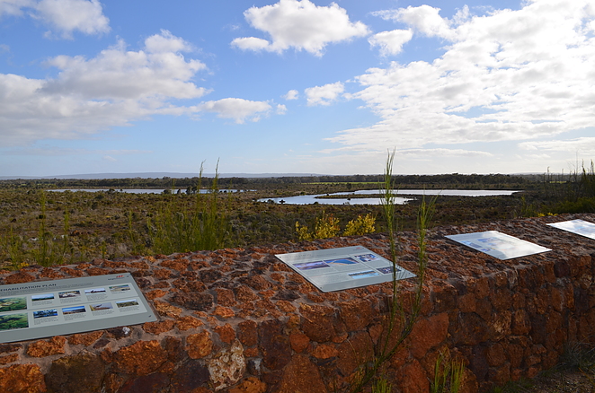
The Beenup mineral sands mine is 17 kilometres north-east of Augusta. The area was explored by BHP Billiton across the 1980's and 1990's. They opened a mine here in 1997 with an expected mine life of 20 years, however it was closed after only two years in April 1999. High levels of clay and sand abrasiveness caused plant maintenance problems, leading to a maximum 60% capacity of plant operations. The company had spent 300 million Australian dollars on the project. Its history is similar to the company's Ravensthorpe nickel mine experience. While the mine was unsuccessful, the rehabilitation of the mine site is considered world class.
Select Mineral List Type
Standard Detailed Gallery Strunz Chemical ElementsMineral List
4 valid minerals.
Rock Types Recorded
Note: data is currently VERY limited. Please bear with us while we work towards adding this information!
Select Rock List Type
Alphabetical List Tree DiagramDetailed Mineral List:
| ⓘ 'Garnet Group' Formula: X3Z2(SiO4)3 |
| ⓘ Ilmenite Formula: Fe2+TiO3 |
| ⓘ 'Monazite Group' Formula: REE(PO4) |
| ⓘ Pyrite Formula: FeS2 |
| ⓘ Rutile Formula: TiO2 |
| ⓘ Zircon Formula: Zr(SiO4) |
Gallery:
List of minerals arranged by Strunz 10th Edition classification
| Group 2 - Sulphides and Sulfosalts | |||
|---|---|---|---|
| ⓘ | Pyrite | 2.EB.05a | FeS2 |
| Group 4 - Oxides and Hydroxides | |||
| ⓘ | Ilmenite | 4.CB.05 | Fe2+TiO3 |
| ⓘ | Rutile | 4.DB.05 | TiO2 |
| Group 9 - Silicates | |||
| ⓘ | Zircon | 9.AD.30 | Zr(SiO4) |
| Unclassified | |||
| ⓘ | 'Monazite Group' | - | REE(PO4) |
| ⓘ | 'Garnet Group' | - | X3Z2(SiO4)3 |
List of minerals for each chemical element
| O | Oxygen | |
|---|---|---|
| O | ⓘ Ilmenite | Fe2+TiO3 |
| O | ⓘ Monazite Group | REE(PO4) |
| O | ⓘ Rutile | TiO2 |
| O | ⓘ Zircon | Zr(SiO4) |
| O | ⓘ Garnet Group | X3Z2(SiO4)3 |
| Si | Silicon | |
| Si | ⓘ Zircon | Zr(SiO4) |
| Si | ⓘ Garnet Group | X3Z2(SiO4)3 |
| P | Phosphorus | |
| P | ⓘ Monazite Group | REE(PO4) |
| S | Sulfur | |
| S | ⓘ Pyrite | FeS2 |
| Ti | Titanium | |
| Ti | ⓘ Ilmenite | Fe2+TiO3 |
| Ti | ⓘ Rutile | TiO2 |
| Fe | Iron | |
| Fe | ⓘ Ilmenite | Fe2+TiO3 |
| Fe | ⓘ Pyrite | FeS2 |
| Zr | Zirconium | |
| Zr | ⓘ Zircon | Zr(SiO4) |
Other Regions, Features and Areas containing this locality
Australia
- Western Australia
- Perth BasinBasin
- Pinjarra OrogenOrogen
Australian PlateTectonic Plate
- Darling OrogenOrogenic Belt
This page contains all mineral locality references listed on mindat.org. This does not claim to be a complete list. If you know of more minerals from this site, please register so you can add to our database. This locality information is for reference purposes only. You should never attempt to
visit any sites listed in mindat.org without first ensuring that you have the permission of the land and/or mineral rights holders
for access and that you are aware of all safety precautions necessary.

Beenup mineral sands mine, Augusta, Augusta-Margaret River Shire, Western Australia, Australia