Log In


Gemtree 'garnet lease', Mount Riddock Station, Harts Range, Central Desert Region, Northern Territory, Australiai
| Regional Level Types | |
|---|---|
| Gemtree 'garnet lease' | - not defined - |
| Mount Riddock Station | Mountain |
| Harts Range | Mountain Range |
| Central Desert Region | Region |
| Northern Territory | Territory |
| Australia | Country |
This page is currently not sponsored. Click here to sponsor this page.
Get Involved with mindat.org
Mindat.org has grown through countless contributions from mineral enthusiasts, collectors, researchers and experts around the world — people just like you.
Want to take part?
1
2
3
4
Contribute
Add photos, locality information and knowledge
Every contribution helps make mindat.org better for everyone.
Latitude & Longitude (WGS84):
23° 0' 34'' South , 134° 22' 44'' East
Latitude & Longitude (decimal):
Köppen climate type:
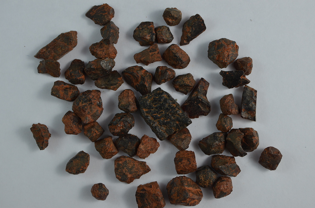
Located between the Gemtree caravan park, and the Mount Riddock pastoral station homestead, just south of the Plenty Highway. From memory when visited several years ago, the area was a private lease for the Gemtree caravan park, who run fossicking tours to the site during the winter months. The area is flat with thick mulga scrub, and its appears some people with a poor sense of direction can get lost, when looking for garnets outside the lease. Garnets are found by digging, sieving, washing, then holding the stones to the sunlight. At first they look black, but the sunlight reveals a deep red colour. They are almandine garnets, up to 2cms across. Some can be faceted which the Gemtree people will cut for you for a fee. They also have a rock shop, and run zircon fossicking tours (See Alcoota Station Mindat sub-heading). Garnets are said to be widespread through the Harts Ranges, and could be found elsewhere.
The following is location details of several garnet fossicking spots in the area, as listed by (A Fossicking Guide to the Northern Territory), some of which may be outside of leases. However, the information is old dating 1986.
(1) Turn south on a signposted track, 34 kilometres east of Gemtree, and garnets are 500 metres south of the Plenty Highway, mainly on the western side of the track - small chips and crystals up to 2 cm in whitish soil. Most are internally fractured, small but are of good colour.
(2) Continue south along this track 2.8 km to the disused Garety Bore (not located), then turn onto a track north-east, then south track 0.7 km to the garnet area, or alternatively take the track south at the grid further east (2.6 km) from the prior entrance track, then head south 2.2 km to the access track- garnets large but of poor quality, found in a creek, and the hillside across from the creek. Some are a few cm in diameter, and smaller fragments of transparent dark reddish brown material.
(3) Continue south of Garety Bore 4 km (track turns south-east), and garnets are found at the junction with a track heading south.
(4) Go 0.7 km further south-east of this junction, then 1.9 kms along a track north to garnets-diggings in red and white soils with extensive pits 50 x 200 metres to one metre depth. Garnets are of various sizes, the smaller ones a beautiful dark pink, and a few free of cracks.
(5) Go 3 km along track south of (3), and take a track west 500 metres to an old mica mine.
Now having said this the area is a maze of tracks and small diggings. The Garety Bore could not be located, although there is a dam nearby, however the above track information does not make sense to it. Tracks may have changed over the years. Alternatively take one of several tracks south of the Plenty Highway, and go exploring, stopping at a likely spot. Please be careful as getting lost in this area is very easy.
Select Mineral List Type
Standard Detailed Gallery Strunz Chemical ElementsGallery:
List of minerals arranged by Strunz 10th Edition classification
| Group 9 - Silicates | |||
|---|---|---|---|
| ⓘ | Almandine | 9.AD.25 | Fe2+3Al2(SiO4)3 |
List of minerals for each chemical element
| O | Oxygen | |
|---|---|---|
| O | ⓘ Almandine | Fe32+Al2(SiO4)3 |
| Al | Aluminium | |
| Al | ⓘ Almandine | Fe32+Al2(SiO4)3 |
| Si | Silicon | |
| Si | ⓘ Almandine | Fe32+Al2(SiO4)3 |
| Fe | Iron | |
| Fe | ⓘ Almandine | Fe32+Al2(SiO4)3 |
Other Regions, Features and Areas containing this locality
Australia
- Arunta OrogenOrogen
- Aileron ProvinceGeologic Province
- North Australian ElementCraton
- Northern Territory
- Barkly Region
- SandoverTown
- Kalkarindji Igneous ProvinceGeologic Province
- Barkly Region
Australian PlateTectonic Plate
- Arunta BlockOrogenic Belt
This page contains all mineral locality references listed on mindat.org. This does not claim to be a complete list. If you know of more minerals from this site, please register so you can add to our database. This locality information is for reference purposes only. You should never attempt to
visit any sites listed in mindat.org without first ensuring that you have the permission of the land and/or mineral rights holders
for access and that you are aware of all safety precautions necessary.

Gemtree 'garnet lease', Mount Riddock Station, Harts Range, Central Desert Region, Northern Territory, Australia