Log In


Sweetwater Mine, Ellington, Reynolds County, Missouri, USAi
| Regional Level Types | |
|---|---|
| Sweetwater Mine | Mine (Active) |
| Ellington | Village |
| Reynolds County | County |
| Missouri | State |
| USA | Country |
Sweetwater Mine, Ellington, Southeast Missouri Lead District, Missouri, USA
Sweetwater Mine, Ellington, Viburnum Trend Mining District, Missouri, USA
This page is currently not sponsored. Click here to sponsor this page.
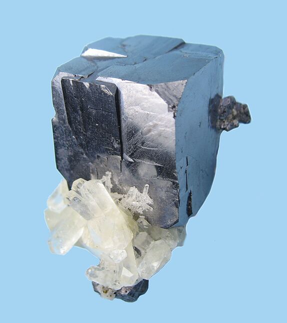



Latitude & Longitude (WGS84):
37° 21' 32'' North , 91° 8' 48'' West
Latitude & Longitude (decimal):
Type:
Mine (Active) - last checked 2022
Köppen climate type:
Nearest Settlements:
| Place | Population | Distance |
|---|---|---|
| Bunker | 400 (2017) | 12.1km |
| Centerville | 188 (2017) | 18.7km |
| Ellington | 960 (2017) | 20.4km |
| Eminence | 587 (2017) | 29.7km |
| Viburnum | 662 (2017) | 39.6km |
Other/historical names associated with this locality:
Milliken Mine; Frank R. Milliken; Blair Creek; Ozark Lead Company Mine; Adair Creek; Logan Creek
A Pb-Zn occurrence/mine located about 12 miles (ca. 19 km) NW of Ellington. Formerly owned & operated by Ozark Lead Company from 1968 to 1986 (although it was not in production from 1983 to 1986 due to low lead prices). Sold to ASARCO in 1986, reopened December 1987. Sold to the Doe Run Company in 1997, and presently in operation.
Reserves in 1988 amounted to 22.6 million tons of ore at an average of 4.84% Pb & 0.59% Zn.
Mining Method: Room and Pillar. Drill+Blast with LHD or mine truck haulage to ore chutes below. After crushing underground, the ore is hauled to a 20-foot diameter x 1,250 foot deep, central 3-compartment hoisting shaft.
Regional Geology: The Viburnum Trend is a 6-mile x 40-mile North-trending deposit discovered in the late 1950s and early 1960s whose Pb-Ag-Zn deposits are exploited by the Brushy Creek, Buick, Fletcher, Magmont, Sweetwater, West Fork, and Viburnum mines Nos. 27, 28, 29, and 35 at depths ranging from 1,000-1,450 feet.
The Viburnum Trend deposits differ from other Mississippi Valley-type lead-zinc ore deposits in that ores are shallower, they include nickel and cobalt minerals, and some copper-iron sulfides. Also, while ores were formed from hot, saline brines, it is generally accepted that for the Viburnum Trend, this was a repetitive precipitation and dissolution process for the sulfides, particularly galena and suggests that the ore-forming base metal constituents were transported with reduced sulfur in the same solutions, with precipitation initiated by a change in pH, dilution, and/or a decrease in temperature. For the Sweetwater ores, the repetitive precipitations comprised decreasing base metal concentrations in the mineralizing fluids.
Most ore minerals are found as sulfides such as galena, sphalerite, and chalcopyrite. Gangue minerals associated with the economic minerals include pyrite, calcite, dolomite, and quartz.
Sweetwater Geology: There are 8 distinct orebodies distributed at depth within the Bonneterre formation. The Bonneterre itself comprises four facies: fore reef, reef complex, back reef, and shelf. These facies are petrographic units developed in response to sea level fluctuations and the distribution of Precambrian knobs and ridges in a shallow Cambrian sea. Oolitic and digitate stromatolite facies predominate in the mine, and stratigraphic relationships record a prograding sedimentary pattern during lower Bonneterre sedimentation that expresses as an interfingering of the planar stromatolitic burrowed lime mudstone (reef complex) facies with the digitate (back reef) facies.
In contrast to most of the other mines in the Viburnum Trend, much of the Ozark Lead Company orebody lies at right angles to the depositional strike of the sediments. This divergence is due to localization of much of the ore along the flank of a northwest-trending Precambrian high situated on the upthrown side of a high-angle reverse fault.
Select Mineral List Type
Standard Detailed Gallery Strunz Chemical ElementsCommodity List
This is a list of exploitable or exploited mineral commodities recorded at this locality.Mineral List
23 valid minerals. 1 erroneous literature entry.
Detailed Mineral List:
Gallery:

List of minerals arranged by Strunz 10th Edition classification
| Group 2 - Sulphides and Sulfosalts | |||
|---|---|---|---|
| ⓘ | Chalcocite | 2.BA.05 | Cu2S |
| ⓘ | Djurleite | 2.BA.05 | Cu31S16 |
| ⓘ | Anilite | 2.BA.10 | Cu7S4 |
| ⓘ | Digenite | 2.BA.10 | Cu9S5 |
| ⓘ | Bornite | 2.BA.15 | Cu5FeS4 |
| ⓘ | Covellite | 2.CA.05a | CuS |
| ⓘ | Sphalerite | 2.CB.05a | ZnS |
| ⓘ | Chalcopyrite | 2.CB.10a | CuFeS2 |
| ⓘ | var. Blistered Copper | 2.CB.10a | CuFeS2 |
| ⓘ | Millerite | 2.CC.20 | NiS |
| ⓘ | Galena | 2.CD.10 | PbS |
| ⓘ | Carrollite | 2.DA.05 | CuCo2S4 |
| ⓘ | Fletcherite | 2.DA.05 | CuNi2S4 |
| ⓘ | Linnaeite ? | 2.DA.05 | Co2+Co3+2S4 |
| ⓘ | Polydymite | 2.DA.05 | Ni2+Ni3+2S4 |
| ⓘ | Siegenite | 2.DA.05 | CoNi2S4 |
| ⓘ | Pyrite | 2.EB.05a | FeS2 |
| ⓘ | Vaesite | 2.EB.05a | NiS2 |
| ⓘ | Marcasite | 2.EB.10a | FeS2 |
| Group 4 - Oxides and Hydroxides | |||
| ⓘ | Quartz | 4.DA.05 | SiO2 |
| Group 5 - Nitrates and Carbonates | |||
| ⓘ | Calcite | 5.AB.05 | CaCO3 |
| ⓘ | Dolomite | 5.AB.10 | CaMg(CO3)2 |
| ⓘ | Malachite | 5.BA.10 | Cu2(CO3)(OH)2 |
| Group 8 - Phosphates, Arsenates and Vanadates | |||
| ⓘ | Erythrite | 8.CE.40 | Co3(AsO4)2 · 8H2O |
| Group 9 - Silicates | |||
| ⓘ | Dickite | 9.ED.05 | Al2(Si2O5)(OH)4 |
| Unclassified | |||
| ⓘ | 'Petroleum var. Bitumen' | - | |
List of minerals for each chemical element
Other Databases
| Link to USGS MRDS: | 10293984 |
|---|
Other Regions, Features and Areas containing this locality
North AmericaContinent
North America PlateTectonic Plate
- Granite-Rhyolite ProvinceMagmatic Province
- Shawnee DomainDomain
USA
- Missouri
- Southeast Missouri Lead DistrictMining District
- Viburnum Trend Mining DistrictMining Sub-district
This page contains all mineral locality references listed on mindat.org. This does not claim to be a complete list. If you know of more minerals from this site, please register so you can add to our database. This locality information is for reference purposes only. You should never attempt to
visit any sites listed in mindat.org without first ensuring that you have the permission of the land and/or mineral rights holders
for access and that you are aware of all safety precautions necessary.
References
[1]Mouat, M. M., Clendenin, C. W. (1977) Geology of the Ozark Lead Company Mine, Viburnum Trend, Southeast Missouri. Economic Geology, 72 (3) 398-407 doi:10.2113/gsecongeo.72.3.398
Roedder, E. (1977) Fluid inclusion studies of ore deposits in the Viburnum Trend, Southeast Missouri. Economic Geology, 72 (3) 474-479 doi:10.2113/gsecongeo.72.3.474
Crocetti, C. A., Holland, Heinrich D., McKenna, L. W. (1988) Isotopic composition of lead in galenas from the Viburnum Trend, Missouri. Economic Geology, 83 (2) 355-376 doi:10.2113/gsecongeo.83.2.355
Niewendorp, C. A., Clendenin, C. W. (1993) Paragenetic link between organic matter and late-stage ore deposition in the Sweetwater Mine, Viburnum Trend, Southeast Missouri. Economic Geology, 88 (4) 957-960 doi:10.2113/gsecongeo.88.4.957
Seeger, Cheryl M. (2008) Chapter 1. History of Mining in the Southeast Missouri Lead District and Description of Mine Processes, Regulatory Controls, Environmental Effects, and Mine Facilities in the Viburnum Trend Subdistrict, in Hydrologic Investigations Concerning Lead Mining Issues in Southeastern Missouri. Scientific Investigations Report, 2008-5140. US Geological Survey. 5-33

Sweetwater Mine, Ellington, Reynolds County, Missouri, USA