Log In


Beckermet Mine, Haile, Copeland, Cumbria, England, UKi
| Regional Level Types | |
|---|---|
| Beckermet Mine | Mine |
| Haile | Civil Parish |
| Copeland | District |
| Cumbria | County |
| England | Constituent Country |
| UK | Country |
This page is currently not sponsored. Click here to sponsor this page.


Latitude & Longitude (WGS84):
54° 27' 47'' North , 3° 30' 15'' West
Latitude & Longitude (decimal):
UK National Grid Reference:
NY025086
Type:
Köppen climate type:
Nearest Settlements:
| Place | Population | Distance |
|---|---|---|
| Beckermet | 704 (2018) | 1.7km |
| Egremont | 6,222 (2018) | 2.3km |
| Moor Row | 787 (2018) | 6.1km |
| Saint Bees | 1,644 (2018) | 6.4km |
| Cleator Moor | 6,936 (2018) | 6.5km |
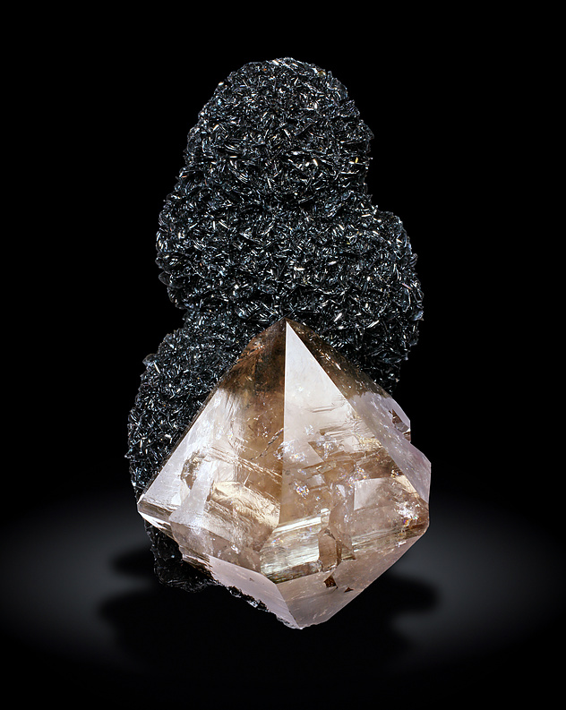
Located south-east of the village of Egremont, The Beckermet Mine was opened in 1903 and closed in 1973. It was one of the later mines in the district and eventually joined underground with the Florence and Ullcoats mines. Primarily worked for iron ore from hematite, the mine complex also produced many specimens, including calcite, quartz, hematite, fluorite, and dolomite. Particularly noteworthy was the find of calcite in the "Banana Slide" fault zone during the early 1970s.
Select Mineral List Type
Standard Detailed Gallery Strunz Chemical ElementsDetailed Mineral List:
| ⓘ Anglesite Formula: PbSO4 |
| ⓘ Calcite Formula: CaCO3 References: |
| ⓘ Chalcanthite Formula: CuSO4 · 5H2O |
| ⓘ Chalcopyrite Formula: CuFeS2 |
| ⓘ Dolomite Formula: CaMg(CO3)2 |
| ⓘ Fluorite Formula: CaF2 |
| ⓘ Hematite Formula: Fe2O3 References: |
| ⓘ Hematite var. Kidney Ore Formula: Fe2O3 References: |
| ⓘ Hematite var. Specularite Formula: Fe2O3 |
| ⓘ Pyrite Formula: FeS2 |
| ⓘ Quartz Formula: SiO2 |
| ⓘ Quartz var. Smoky Quartz Formula: SiO2 |
Gallery:

List of minerals arranged by Strunz 10th Edition classification
| Group 2 - Sulphides and Sulfosalts | |||
|---|---|---|---|
| ⓘ | Chalcopyrite | 2.CB.10a | CuFeS2 |
| ⓘ | Pyrite | 2.EB.05a | FeS2 |
| Group 3 - Halides | |||
| ⓘ | Fluorite | 3.AB.25 | CaF2 |
| Group 4 - Oxides and Hydroxides | |||
| ⓘ | Hematite | 4.CB.05 | Fe2O3 |
| ⓘ | var. Specularite | 4.CB.05 | Fe2O3 |
| ⓘ | var. Kidney Ore | 4.CB.05 | Fe2O3 |
| ⓘ | Quartz | 4.DA.05 | SiO2 |
| ⓘ | var. Smoky Quartz | 4.DA.05 | SiO2 |
| Group 5 - Nitrates and Carbonates | |||
| ⓘ | Calcite | 5.AB.05 | CaCO3 |
| ⓘ | Dolomite | 5.AB.10 | CaMg(CO3)2 |
| Group 7 - Sulphates, Chromates, Molybdates and Tungstates | |||
| ⓘ | Anglesite | 7.AD.35 | PbSO4 |
| ⓘ | Chalcanthite | 7.CB.20 | CuSO4 · 5H2O |
List of minerals for each chemical element
| H | Hydrogen | |
|---|---|---|
| H | ⓘ Chalcanthite | CuSO4 · 5H2O |
| C | Carbon | |
| C | ⓘ Calcite | CaCO3 |
| C | ⓘ Dolomite | CaMg(CO3)2 |
| O | Oxygen | |
| O | ⓘ Anglesite | PbSO4 |
| O | ⓘ Calcite | CaCO3 |
| O | ⓘ Chalcanthite | CuSO4 · 5H2O |
| O | ⓘ Dolomite | CaMg(CO3)2 |
| O | ⓘ Hematite | Fe2O3 |
| O | ⓘ Quartz | SiO2 |
| O | ⓘ Quartz var. Smoky Quartz | SiO2 |
| O | ⓘ Hematite var. Specularite | Fe2O3 |
| O | ⓘ Hematite var. Kidney Ore | Fe2O3 |
| F | Fluorine | |
| F | ⓘ Fluorite | CaF2 |
| Mg | Magnesium | |
| Mg | ⓘ Dolomite | CaMg(CO3)2 |
| Si | Silicon | |
| Si | ⓘ Quartz | SiO2 |
| Si | ⓘ Quartz var. Smoky Quartz | SiO2 |
| S | Sulfur | |
| S | ⓘ Anglesite | PbSO4 |
| S | ⓘ Chalcopyrite | CuFeS2 |
| S | ⓘ Chalcanthite | CuSO4 · 5H2O |
| S | ⓘ Pyrite | FeS2 |
| Ca | Calcium | |
| Ca | ⓘ Calcite | CaCO3 |
| Ca | ⓘ Dolomite | CaMg(CO3)2 |
| Ca | ⓘ Fluorite | CaF2 |
| Fe | Iron | |
| Fe | ⓘ Chalcopyrite | CuFeS2 |
| Fe | ⓘ Hematite | Fe2O3 |
| Fe | ⓘ Pyrite | FeS2 |
| Fe | ⓘ Hematite var. Specularite | Fe2O3 |
| Fe | ⓘ Hematite var. Kidney Ore | Fe2O3 |
| Cu | Copper | |
| Cu | ⓘ Chalcopyrite | CuFeS2 |
| Cu | ⓘ Chalcanthite | CuSO4 · 5H2O |
| Pb | Lead | |
| Pb | ⓘ Anglesite | PbSO4 |
Other Regions, Features and Areas containing this locality
British and Irish IslesGroup of Islands
Eurasian PlateTectonic Plate
- AvaloniaVolcanic Arc
EuropeContinent
UK
- England
- Cumbria
- Copeland
- West Cumberland Iron FieldOre Field
- Copeland
- Cumbria
This page contains all mineral locality references listed on mindat.org. This does not claim to be a complete list. If you know of more minerals from this site, please register so you can add to our database. This locality information is for reference purposes only. You should never attempt to
visit any sites listed in mindat.org without first ensuring that you have the permission of the land and/or mineral rights holders
for access and that you are aware of all safety precautions necessary.

Beckermet Mine, Haile, Copeland, Cumbria, England, UK