Log In


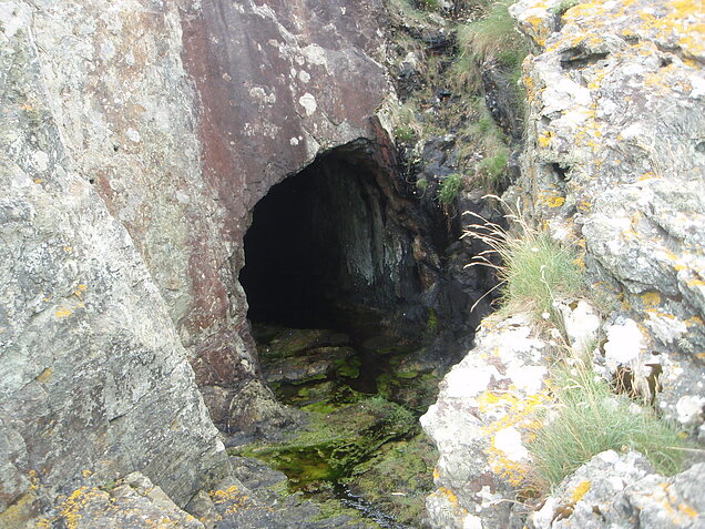
Pant-y-Gaseg Mine, Amlwch, Isle of Anglesey, Wales, UKi
| Regional Level Types | |
|---|---|
| Pant-y-Gaseg Mine | Mine (Abandoned) |
| Amlwch | Community |
| Isle of Anglesey | County |
| Wales | Country |
| UK | Country |
This page is currently not sponsored. Click here to sponsor this page.


Latitude & Longitude (WGS84):
53° 25' 23'' North , 4° 23' 24'' West
Latitude & Longitude (decimal):
UK National Grid Reference:
SH412945
Type:
Mine (Abandoned) - last checked 2020
Köppen climate type:
Nearest Settlements:
| Place | Population | Distance |
|---|---|---|
| Amlwch | 3,211 (2017) | 3.2km |
| Cemaes Bay | 1,187 (2017) | 4.3km |
| Llanfechell | 589 (2017) | 5.6km |
| Penysarn | 595 (2017) | 6.1km |
| Llanerchymedd | 1,133 (2017) | 10.3km |
Other/historical names associated with this locality:
Gwynedd;
A trial adit of 662 feet that was driven for copper at Pant Y Gaseg just west of Bull bay in 1859. Around 1872 a second attempt was made, with a small shaft being sunk on the ridge.
A report in the Mining Journal of Sept 1872 notes that "....The copper is of the same description as Mona mine. We also saw some of the beautiful umber and ocrhe taken out in our presence. We were amazed at the Kaolinite [dickite]. It is our impression that this will be a great mine very shortly".
Altghough the Panty-gaseg Copper Mining Company issued 40 shares at £250 pounds each in 1872, the company was disolved in 1879. The area was operated again by another company called the New Cambrain Syndicate from 1906 to 1907.
Select Mineral List Type
Standard Detailed Gallery Strunz Chemical ElementsCommodity List
This is a list of exploitable or exploited mineral commodities recorded at this locality.Mineral List
6 valid minerals. 1 (TL) - type locality of valid minerals.
Detailed Mineral List:
| ⓘ Azurite Formula: Cu3(CO3)2(OH)2 |
| ⓘ Chalcopyrite Formula: CuFeS2 |
| ⓘ Dickite (TL) Formula: Al2(Si2O5)(OH)4 Type Locality: |
| ⓘ Dolomite Formula: CaMg(CO3)2 |
| ⓘ 'Limonite' |
| ⓘ Malachite Formula: Cu2(CO3)(OH)2 |
| ⓘ Quartz Formula: SiO2 References: |
Gallery:

List of minerals arranged by Strunz 10th Edition classification
| Group 2 - Sulphides and Sulfosalts | |||
|---|---|---|---|
| ⓘ | Chalcopyrite | 2.CB.10a | CuFeS2 |
| Group 4 - Oxides and Hydroxides | |||
| ⓘ | Quartz | 4.DA.05 | SiO2 |
| Group 5 - Nitrates and Carbonates | |||
| ⓘ | Dolomite | 5.AB.10 | CaMg(CO3)2 |
| ⓘ | Azurite | 5.BA.05 | Cu3(CO3)2(OH)2 |
| ⓘ | Malachite | 5.BA.10 | Cu2(CO3)(OH)2 |
| Group 9 - Silicates | |||
| ⓘ | Dickite (TL) | 9.ED.05 | Al2(Si2O5)(OH)4 |
| Unclassified | |||
| ⓘ | 'Limonite' | - | |
List of minerals for each chemical element
| H | Hydrogen | |
|---|---|---|
| H | ⓘ Azurite | Cu3(CO3)2(OH)2 |
| H | ⓘ Dickite | Al2(Si2O5)(OH)4 |
| H | ⓘ Malachite | Cu2(CO3)(OH)2 |
| C | Carbon | |
| C | ⓘ Azurite | Cu3(CO3)2(OH)2 |
| C | ⓘ Dolomite | CaMg(CO3)2 |
| C | ⓘ Malachite | Cu2(CO3)(OH)2 |
| O | Oxygen | |
| O | ⓘ Azurite | Cu3(CO3)2(OH)2 |
| O | ⓘ Dickite | Al2(Si2O5)(OH)4 |
| O | ⓘ Dolomite | CaMg(CO3)2 |
| O | ⓘ Malachite | Cu2(CO3)(OH)2 |
| O | ⓘ Quartz | SiO2 |
| Mg | Magnesium | |
| Mg | ⓘ Dolomite | CaMg(CO3)2 |
| Al | Aluminium | |
| Al | ⓘ Dickite | Al2(Si2O5)(OH)4 |
| Si | Silicon | |
| Si | ⓘ Dickite | Al2(Si2O5)(OH)4 |
| Si | ⓘ Quartz | SiO2 |
| S | Sulfur | |
| S | ⓘ Chalcopyrite | CuFeS2 |
| Ca | Calcium | |
| Ca | ⓘ Dolomite | CaMg(CO3)2 |
| Fe | Iron | |
| Fe | ⓘ Chalcopyrite | CuFeS2 |
| Cu | Copper | |
| Cu | ⓘ Azurite | Cu3(CO3)2(OH)2 |
| Cu | ⓘ Chalcopyrite | CuFeS2 |
| Cu | ⓘ Malachite | Cu2(CO3)(OH)2 |
Other Regions, Features and Areas containing this locality
This page contains all mineral locality references listed on mindat.org. This does not claim to be a complete list. If you know of more minerals from this site, please register so you can add to our database. This locality information is for reference purposes only. You should never attempt to
visit any sites listed in mindat.org without first ensuring that you have the permission of the land and/or mineral rights holders
for access and that you are aware of all safety precautions necessary.

Pant-y-Gaseg Mine, Amlwch, Isle of Anglesey, Wales, UK