Log In


Eersteling mine, Pietersburg greenstone belt, Capricorn District Municipality, Limpopo, South Africai
| Regional Level Types | |
|---|---|
| Eersteling mine | Mine |
| Pietersburg greenstone belt | Belt |
| Capricorn District Municipality | District |
| Limpopo | Province |
| South Africa | Country |
This page is currently not sponsored. Click here to sponsor this page.


Latitude & Longitude:
23° South , 29° East (est.)
Estimate based on other nearby localities or region boundaries.
Margin of Error:
~150km
Type:
Between Polokwane (Pietersburg) and the town of Mokopane (Potgietersrus).
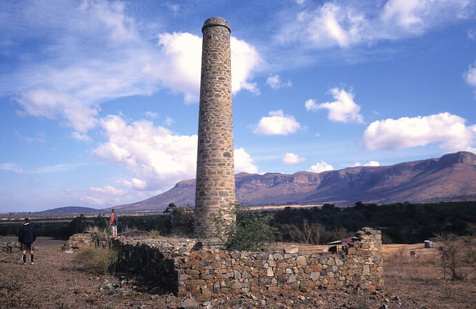
The Eersteling Goldfield is located in the Pietersburg greenstone belt, on the farm Eersteling 17KS. This site is of historic importance and significance because it was the site of the first lode gold deposit discovered in the Transvaal in 1871. A boiler house with a 25 metre-high chimney was erected in 1872 and the remains of these buildings, including the chimney stack, have been declared a National Monument. The ore that was processed was at first crushed on a stone pavement which can still be seen on the banks of the Eersteling stream about 275m upstream from the National Monument.
Mining operations were carried out sporadically by small companies, syndicates and one-man operations after the initial discovery. During the 1930's mining activities experienced a revival due to the increase in the gold price.
GEOLOGY
Three main ore zones have been identified in the Eersteling Goldfield. They represent shear zones which strike east-west, dip steeply south, and have an average width of about 80 cm. The Pienaar Reef has a strike length of 6 kilometres and represents a series of boudinaged and brecciated quartz-carbonate veins, which are associated with abundant sulphides including pyrrhotite, chalcopyrite, pyrite and arsenopyrite. The Girlie Reef is a branch of the Pienaar Reef and occurs in close vicinity to a band of ferruginous schists. The reef consists of a quartz-carbonate-chlorite rock, containing quartz-filled fractures which carry gold and arsenopyrite. The Doreen Reef is situated south of the Pienaar and Girlie Reefs and occurs in ferruginous schists. Fracture fillings in chert clasts and quartz boudins contain abundant arsenopyrite with gold. Another gold-bearing area is that of the Clarke's and Malan's workings south of the three main zones on the farm Vrischgewaagd 33 KS, but these workings never yielded significant amounts of gold.
The gold ores can be divided into three main groups, namely finely disseminated gold in quartz veins and which have gold along wall rock contacts; shear zones of impregnated gold-bearing schists; and weathered zones of supergene enrichments.
It is the latter type which most likely accounted for some of the larger specimens found in the area. For example, in December 1871 Thomas Baines, the renowned explorer and artist, visited the Eersteling Goldfield and describes some of the gold that he saw there:
"We were kindly welcomed by him (Button) and Mrs Button, and were fortunate in being just in time so see some very beautiful specimens of gold quartz, which were already packed to be sent to the diamond fields; some were very rich, and a few, collected by Mrs Button, exceedingly so. A regular network of gold standing out in high relief all over the stones and looking like a filigree of gold thread".
In 1936 a 2.395kg nugget was found at Eersteling, and in 1948 a 1.445kg nugget was discovered.
Reference: Cairncross and Dixon (1995)
Select Mineral List Type
Standard Detailed Gallery Strunz Chemical ElementsDetailed Mineral List:
| ⓘ Native Gold Formula: Au |
Gallery:
List of minerals arranged by Strunz 10th Edition classification
| Group 1 - Elements | |||
|---|---|---|---|
| ⓘ | Native Gold | 1.AA.05 | Au |
List of minerals for each chemical element
| Au | Gold | |
|---|---|---|
| Au | ⓘ Native Gold | Au |
Other Regions, Features and Areas containing this locality
This page contains all mineral locality references listed on mindat.org. This does not claim to be a complete list. If you know of more minerals from this site, please register so you can add to our database. This locality information is for reference purposes only. You should never attempt to
visit any sites listed in mindat.org without first ensuring that you have the permission of the land and/or mineral rights holders
for access and that you are aware of all safety precautions necessary.

Eersteling mine, Pietersburg greenstone belt, Capricorn District Municipality, Limpopo, South Africa